SHOP BY YEAR :: FOR OFFICE :: FOR CLASSROOM :: GIFT IDEAS :: CUSTOMER SERVICE

Map of Discovery: Western Hemisphere
Issue: January 1929
More Views
Enlarge Image
ZoomClick here to zoom!
Purchase Product :
Please select map format:
Laminated   
18.5" x 16.5" - $19.95
Laminated-w/Plastic Rails  (What are rails?)
18.5" x 16.5" - $29.95
Paper
18.5" x 16.5" - $14.95
Wallzilla Adhesive Format
18.5" x 16.5" - $34.95
Also Available Framed
Also Available Mounted
Product Highlights
Map of Discovery: Western Hemisphere
Item#: X NGC 011929

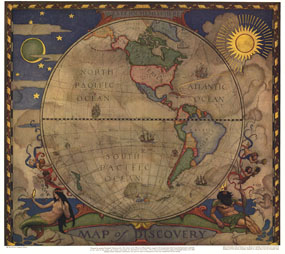
In 1927, famed American painter N. C. Wyeth completed a series of five murals for Hubbard Memorial Hall, the National Geographic Society's first formal library. The Map of Discovery: Western Hemisphere, published in January 1929, is one of those outstanding murals. It features Poseidon and a mermaid keeping watch over the oceans as well as the routes of explorers and dates of expeditions.

The 1929 "Map of Discovery: Western Hemisphere" map features:
• North America and South America with political boundaries as they existed in 1927
• Ocean routes of explorers and the year they traveled them
• Illuminated mariners' chart style
• Beautiful border art of Poseidon and a mermaid

Coverage Area: Western Hemisphere, including North America, South America

More Product Details

This map requires 7 business days to print and laminate prior to shipping.

Appearing in the January 1929 issue of the National Geographic Magazine, this Map of Discovery: Western Hemisphere has been reproduced from its original cartography in order to bring to life a beautiful poster previously only seen in National Geographic Magazine. This reproduction holds true to the high standards that National Geographic Maps are known for.

The Paper version is printed on high quaility semi-gloss paper, perfect for framing.

The Laminated version uses 3mm laminate on both sides for durability, is easy to clean and markable.

From the National Geographic Classic Maps collection, this reproduction is just one of hundreds of titles available here. These maps are Printed on Demand. Sizes are approximate and may vary due to the nature of the trimming and laminating processes.
Shipping Conditions
Maps.com ships to Dometic US only

US FlagThis product can only be shipped to the Domestic U.S.A. (No APO's or PO Boxes)
TimeThis map requires 2 business days to print and laminate prior to shipping.