SHOP BY YEAR :: FOR OFFICE :: FOR CLASSROOM :: GIFT IDEAS :: CUSTOMER SERVICE

Northern And Southern Hemispheres Map
Issue: April 1943
More Views
Enlarge Image
ZoomClick here to zoom!
Purchase Product :
Please select map format:
Laminated   
41" x 22" - $59.95
Laminated-w/Plastic Rails  (What are rails?)
41" x 22" - $76.95
Paper
41" x 22" - $49.95
Wallzilla Adhesive Format
41" x 22" - $89.95
Product Highlights
Northern And Southern Hemispheres Map
Item#: X NGC 041943

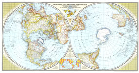
A true classic, this world map first published in April of 1943, shows the northern and southern hemisphers side by side, to give the viewer a perspective that centers each hemisphere on its pole. New to this map were special insets showing airline distances in the Eastern, Western, Northern, and Southern Hemispheres. Stunning cartography and special details make this a marvelous collectors edition.

The 1943 Northern and Southern Hemispheres map features:
• Dual hemisphere map that shows the Northern and Southern Hemispheres side by side
• International boundaries, along with thousands of place names
• "Star projection" world map inset showing world vegetation
• Insets for airline distances between major cities in the Northern, Southern, Eastern, and Western Hemispheres
• Inset showing international time zones

Coverage Area: The World, North America, South America, Africa, Asia, Australia, Europe, Oceania, Antarctica

More Product Details

This map requires 7 business days to print and laminate prior to shipping.

Appearing in the April 1943 issue of the National Geographic Magazine, this Northern And Southern Hemispheres map has been reproduced from its original cartography in order to bring to life a beautiful poster previously only seen in National Geographic Magazine. This reproduction holds true to the high standards that National Geographic Maps are known for.

Perfect for home, office or classroom, this map also makes a great gift. Map collectors will surely want to add this map to their library.

The Paper version is printed on high quaility semi-gloss paper, perfect for framing.

The Laminated version uses 3mm laminate on both sides for durability, is easy to clean and markable.

From the National Geographic Classic Maps collection, this reproduction is just one of hundreds of titles available here. These maps are Printed on Demand. Sizes are approximate and may vary due to the nature of the trimming and laminating processes.
Shipping Conditions
Maps.com ships to Dometic US only

US FlagThis product can only be shipped to the Domestic U.S.A. (No APO's or PO Boxes)
TimeThis map requires 2 business days to print and laminate prior to shipping.