 |
|
|
|
|
Earths Dynamic Crust Map
Issue: August 1985
|
|
|
|
|
|
|
| Product Highlights |
| Earths Dynamic Crust Map |
| Item#: X NGC 081985a |
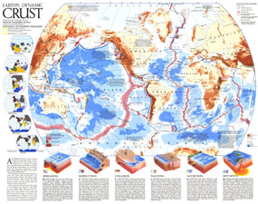
Explore the forces behind the shaping of our planet with the fascinating Earth's Dynamic Crust map. Half of a two-map set published in August 1985, this map was accompanied by "The Shaping of a Continent: North America's Active West" map and the article "Our Restless Planet Earth." This map explains the various forms of tectonic activity such as hot spots, accretion, subduction, and spreading, and includes the locations of volcanoes and the earthquakes of 6.0 magnitude or greater which occurred from 1975-1985. The 1985 Earth's Dynamic Crust map features:
• Six inset maps showing the location of the continents from 540 million years ago to the present
• Insets illustrating and explaining spreading, subduction, collision, faulting, accretion, and hot spots
• Active tectonic features including trenches, faults, spreading ridges, hot spots, and selected volcanoes
• Earthquake epicenters of 6.0 magnitude or greater that occurred from 1975-1985
• Land heights and water depths
• An abundance of notes
• Plate motion noted in mm/year
Coverage Area: The World
|
|
 |
More Product Details
This map requires 7 business days to print and laminate prior to shipping.
Appearing in the August 1985 issue of the National Geographic Magazine, this Earths Dynamic Crust map has been reproduced from its original cartography in order to bring to life a beautiful poster previously only seen in National Geographic Magazine. This reproduction holds true to the high standards that National Geographic Maps are known for.
Perfect for home, office or classroom, this map also makes a great gift. Map collectors will surely want to add this map to their library.
The Paper version is printed on high quaility semi-gloss paper, perfect for framing.
The Laminated version uses 3mm laminate on both sides for durability, is easy to clean and markable.
From the National Geographic Classic Maps collection, this reproduction is just one of hundreds of titles available here. These maps are Printed on Demand. Sizes are approximate and may vary due to the nature of the trimming and laminating processes.
|
|
Shipping Conditions
Maps.com ships to Dometic US only
 | This product can only be shipped to the Domestic U.S.A. (No APO's or PO Boxes) |  | This map requires 2 business days to print and laminate prior to shipping. |
|
|
|
|


 Click here to zoom!