SHOP BY YEAR :: FOR OFFICE :: FOR CLASSROOM :: GIFT IDEAS :: CUSTOMER SERVICE

The Shaping Of A Continent Map
Issue: August 1985
More Views
Enlarge Image
ZoomClick here to zoom!
Purchase Product :
Please select map format:
Laminated   
22.5" x 18" - $19.95
Laminated-w/Plastic Rails  (What are rails?)
22.5" x 18" - $29.95
Paper
22.5" x 18" - $14.95
Wallzilla Adhesive Format
22.5" x 18" - $34.95
Product Highlights
The Shaping Of A Continent Map
Item#: X NGC 081985b

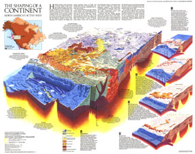
Half of a two-map set, the "Shaping of a Continent: North America's Active West" map features detail of the one of the most active tectonic areas in the world. Published in August 1985, this map accompanied the "Earth's Dynamic Crust" map and the article "Our Restless Planet Earth."

The 1985 Shaping of a Continent: North Americas Active West map features:
• A cross-section of the region in the present day
• Notes about terranes, the Juan de Fuca plate, marine transgressions, batholiths, basin and range, the Columbia River plateau, the Snake River plain, and the Laramide Orogeny
• Four inset maps showing the formation of the west coast region over the last 90 million years
• An inset map illustrating 90 million years of continental drift

Coverage Area: Oregon, Idaho, Wyoming, northern California, northern Nevada, northern Utah, northern Colorado, southern Washington, southern Montana

More Product Details

This map requires 7 business days to print and laminate prior to shipping.

Appearing in the August 1985 issue of the National Geographic Magazine, this Earths Dynamic Crust The Shaping Of A Continent map has been reproduced from its original cartography in order to bring to life a beautiful poster previously only seen in National Geographic Magazine. This reproduction holds true to the high standards that National Geographic Maps are known for.

Perfect for home, office or classroom, this map also makes a great gift. Map collectors will surely want to add this map to their library.

The Paper version is printed on high quaility semi-gloss paper, perfect for framing.

The Laminated version uses 3mm laminate on both sides for durability, is easy to clean and markable.

From the National Geographic Classic Maps collection, this reproduction is just one of hundreds of titles available here. These maps are Printed on Demand. Sizes are approximate and may vary due to the nature of the trimming and laminating processes.
Shipping Conditions
Maps.com ships to Dometic US only

US FlagThis product can only be shipped to the Domestic U.S.A. (No APO's or PO Boxes)
TimeThis map requires 2 business days to print and laminate prior to shipping.