SHOP BY YEAR :: FOR OFFICE :: FOR CLASSROOM :: GIFT IDEAS :: CUSTOMER SERVICE

Physical World Map 1975
Issue: November 1975
More Views
Enlarge Image
ZoomClick here to zoom!
Purchase Product :
Please select map format:
Laminated   
35" x 24" - $39.95
Laminated-w/Plastic Rails  (What are rails?)
35" x 24" - $51.95
Paper
35" x 24" - $29.95
Wallzilla Adhesive Format
35" x 24" - $59.95
Product Highlights
Physical World Map 1975
Item#: X NGC 111975b

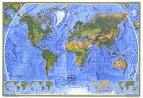
The splendor and beauty of the worlds natural features come to life in this beautiful physical world map, first published in November 1975. The Physical World captures the natural look of the land and oceans of the Earth as only National Geographic can. Mountain ranges, major rivers, vegetation zones, and deserts are dramatically shown, along with major physical features named to provide easy reference. This is a must-have for anyone interested in the natural features of the Earth.

The 1975 Physical World features:
• Physical features for all seven continents
• Mountain ranges with beautiful relief shading
• Major vegetation zones to easily visualize everything from the densest forests to the most barren deserts
• Ocean floor topography, showing major underwater features
• Insets include ocean currents, wind currents, food production and vegetation, and the Earths crust

Coverage Area: The World, North America, South America, Africa, Asia, Australia, Europe, Oceania, Antarctica

More Product Details

This map requires 7 business days to print and laminate prior to shipping.

Appearing in the November 1975 issue of the National Geographic Magazine, this Physical World map has been reproduced from its original cartography in order to bring to life a beautiful poster previously only seen in National Geographic Magazine. This reproduction holds true to the high standards that National Geographic Maps are known for.

Perfect for home, office or classroom, this map also makes a great gift. Map collectors will surely want to add this map to their library.

The Paper version is printed on high quaility semi-gloss paper, perfect for framing.

The Laminated version uses 3mm laminate on both sides for durability, is easy to clean and markable.

From the National Geographic Classic Maps collection, this reproduction is just one of hundreds of titles available here. These maps are Printed on Demand. Sizes are approximate and may vary due to the nature of the trimming and laminating processes.
Shipping Conditions
Maps.com ships to Dometic US only

US FlagThis product can only be shipped to the Domestic U.S.A. (No APO's or PO Boxes)
TimeThis map requires 2 business days to print and laminate prior to shipping.