SHOP BY YEAR :: FOR OFFICE :: FOR CLASSROOM :: GIFT IDEAS :: CUSTOMER SERVICE

World Map 1922
Issue: December 1922
More Views
Enlarge Image
ZoomClick here to zoom!
Purchase Product :
Please select map format:
Laminated   
41.5" x 28" - $59.95
Laminated-w/Plastic Rails  (What are rails?)
41.5" x 28" - $76.95
Paper
41.5" x 28" - $49.95
Wallzilla Adhesive Format
41.5" x 28" - $89.95
Product Highlights
World Map 1922
Item#: X NGC 121922

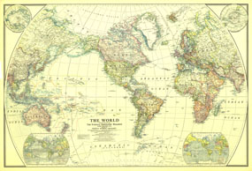
This classic world map, published in December of 1922, shows the worlds political boundaries established following WWI. This map also shows airplane routes that had been established, as well as railroad routes.

The 1922 World map features:
• Classic National Geographic cartography and detail
• Country borders highlighted in color, including borders established after WWI
• Thousands of place names, including country capitals
• Insets of the northern and southern hemispheres
• Inset showing Natural Vegetation and Ocean Currents
• Inset showing Population Density and Prevailing Winds
• Airplane routes in operation, routes that were established but not yet in operation, and Railroad routes

Coverage Area: The World, North America, South America, Africa, Asia, Australia, Europe, Oceania, Antarctica

More Product Details

This map requires 7 business days to print and laminate prior to shipping.

Appearing in the December 1922 issue of the National Geographic Magazine, this World map has been reproduced from its original cartography in order to bring to life a beautiful poster previously only seen in National Geographic Magazine. This reproduction holds true to the high standards that National Geographic Maps are known for.

Perfect for home, office or classroom, this map also makes a great gift. Map collectors will surely want to add this map to their library.

The Paper version is printed on high quaility semi-gloss paper, perfect for framing.

The Laminated version uses 3mm laminate on both sides for durability, is easy to clean and markable.

From the National Geographic Classic Maps collection, this reproduction is just one of hundreds of titles available here. These maps are Printed on Demand. Sizes are approximate and may vary due to the nature of the trimming and laminating processes.
Shipping Conditions
Maps.com ships to Dometic US only

US FlagThis product can only be shipped to the Domestic U.S.A. (No APO's or PO Boxes)
TimeThis map requires 2 business days to print and laminate prior to shipping.