SHOP BY YEAR :: FOR OFFICE :: FOR CLASSROOM :: GIFT IDEAS :: CUSTOMER SERVICE

World Map 1943
Issue: December 1943
More Views
Enlarge Image
ZoomClick here to zoom!
Purchase Product :
Please select map format:
Laminated   
41" x 26" - $59.95
Laminated-w/Plastic Rails  (What are rails?)
41" x 26" - $76.95
Paper
41" x 26" - $49.95
Wallzilla Adhesive Format
41" x 26" - $89.95
Also Available Framed
Also Available Mounted
Product Highlights
World Map 1943
Item#: X NGC 121943

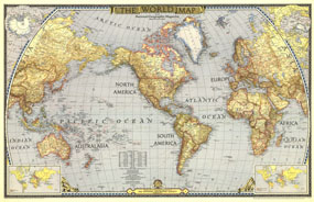
National Geographic published this classic world map in December 1943, in the midst of WWII. Compared to many of the other world maps by the National Geographic Society, this one had a decidedly dark cast, possibly a reflection of the tone of discouragement felt by many as the War continued on. A perfect companion to the World maps of 1951 and 1970.

The 1943 World map features:
• International boundaries as of Sept. 1, 1939
• Insets for the Northern and Southern Hemispheres
• An inset showing the world alliances during WWI
• An inset showing the alliances in WWII as of the publication of this map
• Classic colorization depicting mountain ranges and areas of high elevation
• Ocean currents and time zones

Coverage Area: The World, North America, South America, Africa, Asia, Australia, Europe, Oceania, Antarctica

More Product Details

This map requires 7 business days to print and laminate prior to shipping.

Appearing in the December 1943 issue of the National Geographic Magazine, this World Map map has been reproduced from its original cartography in order to bring to life a beautiful poster previously only seen in National Geographic Magazine. This reproduction holds true to the high standards that National Geographic Maps are known for.

Perfect for home, office or classroom, this map also makes a great gift. Map collectors will surely want to add this map to their library.

The Paper version is printed on high quaility semi-gloss paper, perfect for framing.

The Laminated version uses 3mm laminate on both sides for durability, is easy to clean and markable.

From the National Geographic Classic Maps collection, this reproduction is just one of hundreds of titles available here. These maps are Printed on Demand. Sizes are approximate and may vary due to the nature of the trimming and laminating processes.
Shipping Conditions
Maps.com ships to Dometic US only

US FlagThis product can only be shipped to the Domestic U.S.A. (No APO's or PO Boxes)
TimeThis map requires 2 business days to print and laminate prior to shipping.