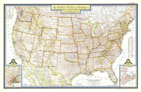
Beautiful cartography and attention to detail are the hallmarks of this beautiful United States map, first published in the June, 1951. The map shows all the major highways of the time, along with a key to national parks and monuments in the US and provincial parks in southern Canada. A perfect companion to the world map published in December of the same year. The 1951 United States map features:
• Full coverage of the 48 states in 1951
• Southern Canada and northern Mexico
• Thousands of place names, including state capitals
• Major roads, rivers, lakes, mountain ranges and elevations
• An detailed inset for New York City
• An inset listing the national parks and monuments in the US, and provincial parks in Canada, as keyed to the map
• An inset for the area of Canada east of Maine
Coverage Area: Continental US, southern Canada, Northern Mexico, New York City
|


 Click here to zoom!
