 |
|
|
|
|
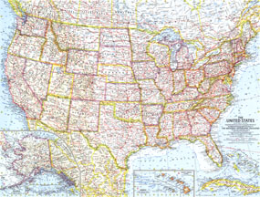
United States Of America Map 1961
Issue: July 1961
|
|
|
|
|
|
|
| Product Highlights |
| United States Of America Map 1961 |
| Item#: X NGC 071961 |
The first US map published by National Geographic following the statehood of Alaska and Hawaii. Also on this map is the first one to show the beginnings of the Freeway system that soon became the Interstate Highway system. This July 1961 map is a great historical reference, and a perfect addtion to any map collection. The 1961 United States map features:
• Coverage of all 50 states, with beautiful insets for Hawaii and Alaska
• Thousands of place names, including state capitals, cities, and towns
• Mountain ranges with beautiful relief shading
• Major roads including existing and "under-construction" freeways, rivers, lakes, mountain ranges and elevations
• Stars denoting places with scheduled air service, and icons for missile tracking stations
• A marked path showing the Appalachian Trail
• Soundings in fathoms
Coverage Area: United States, Alaska, Hawaii
|
|
 |
More Product Details
This map requires 7 business days to print and laminate prior to shipping.
Appearing in the July 1961 issue of the National Geographic Magazine, this United States Of America map has been reproduced from its original cartography in order to bring to life a beautiful poster previously only seen in National Geographic Magazine. This reproduction holds true to the high standards that National Geographic Maps are known for.
Perfect for home, office or classroom, this map also makes a great gift. Map collectors will surely want to add this map to their library.
The Paper version is printed on high quaility semi-gloss paper, perfect for framing.
The Laminated version uses 3mm laminate on both sides for durability, is easy to clean and markable.
From the National Geographic Classic Maps collection, this reproduction is just one of hundreds of titles available here. These maps are Printed on Demand. Sizes are approximate and may vary due to the nature of the trimming and laminating processes.
|
|
Shipping Conditions
Maps.com ships to Dometic US only
 | This product can only be shipped to the Domestic U.S.A. (No APO's or PO Boxes) |  | This map requires 2 business days to print and laminate prior to shipping. |
|
|
|
|


 Click here to zoom!