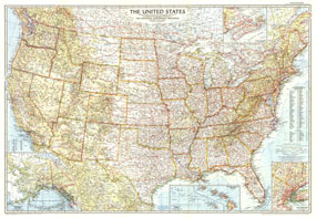
Stunning cartography, superb detail, and new insets for the Territories of Alaska and Hawaii make this US map a classic. Published in September of 1956, prior to the statehood of Alaska and Hawaii, the US map is a perfect addtion to the collection of any map afficionado. The 1956 United States map features:
• Thousands of cities and towns, classified by their population
• State and international boundaries
• Mountain ranges with beautiful relief shading
• Waterways, national parks, and national monuments
• Special insets showing the Territories of Hawaii and Alaska
• Inset for New York City
• Superb detail for southern Canada and northern Mexico
Coverage Area: United States, southern Canada, northern Mexico
|


 Click here to zoom!
