|
|
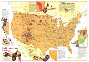
Native American Heritage Map 1991
Issue: October 1991

|
|
|
|
|
|
|
| Product Highlights |
| Native American Heritage Map 1991 |
| Item#: X NGC 101991a |
This educational map reveals tribal and archaeological sites across the United States including federal reservations and museums. Published in October 1991, this map accompanied seven articles on America before Columbus and an additional map entitled "Indian America - What You Can Visit Today" which includes the index to this map. A wonderful map for those interested in exploring Native America. The 1991 Native American Heritage map features:
• Information about the four regions and how they greatly defined the lives of the nations first inhabitants
• Selected Native American sites including tribal centers or museums; archaeological or historical sites; and museums with Native American exhibits
• Federal Indian reservations
• Selected national parks, recreation areas, and monuments
• Interstate highways and other roads
• Illustrations of Native American artifacts
Coverage Area: United States, southern Canada
|
|
More Product Details
This map requires 7 business days to print and laminate prior to shipping.
Appearing in the October 1991 issue of the National Geographic Magazine, this Native American Heritage map has been reproduced from its original cartography in order to bring to life a beautiful poster previously only seen in National Geographic Magazine. This reproduction holds true to the high standards that National Geographic Maps are known for.
Perfect for home, office or classroom, this map also makes a great gift. Map collectors will surely want to add this map to their library.
The Paper version is printed on high quaility semi-gloss paper, perfect for framing.
The Laminated version uses 3mm laminate on both sides for durability, is easy to clean and markable.
From the National Geographic Classic Maps collection, this reproduction is just one of hundreds of titles available here. These maps are Printed on Demand. Sizes are approximate and may vary due to the nature of the trimming and laminating processes.
|
|
Shipping Conditions
Maps.com ships to Dometic US only
 | This product can only be shipped to the Domestic U.S.A. (No APO's or PO Boxes) |  | This map requires 2 business days to print and laminate prior to shipping. |
|


 Click here to zoom!