SHOP BY YEAR :: FOR OFFICE :: FOR CLASSROOM :: GIFT IDEAS :: CUSTOMER SERVICE

Alaska Map 1918
Issue: February 1914
More Views
Enlarge Image
ZoomClick here to zoom!
Purchase Product :
Please select map format:
Laminated   
21.5" x 16" - $19.95
Laminated-w/Plastic Rails  (What are rails?)
21.5" x 16" - $29.95
Paper
21.5" x 16" - $14.95
Wallzilla Adhesive Format
21.5" x 16" - $34.95
Product Highlights
Alaska Map 1918
Item#: X NGC 021914

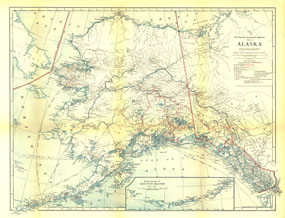
Published in February 1914 with the article "The Nation's Undeveloped Resources," the Map of Alaska contains an abundance of details showing the growing human settlement of the region. U.S. public schools for natives, post offices, telegraph stations, mail routes, and mission stations are just some of the many features shown on this map.

The 1914 Alaska map features:
• Inset map of the western extension of the Aleutian Islands
• Cities, towns, and settlements
• Railroads and steamship lines
• Telegraph stations, wireless telegraph stations, post offices, telegraph and cable lines, and overland postal routes
• Mission stations, U.S. public schools for natives, military reservations, Northwest Mounted Police stations, mines, and lighthouses
• Volcanoes, mountains, rivers, lakes, and glaciers
• Approximate southern limit of winter ice

Coverage Area: Alaska, western Yukon Territory

More Product Details

This map requires 7 business days to print and laminate prior to shipping.

Appearing in the February 1914 issue of the National Geographic Magazine, this Alaska map has been reproduced from its original cartography in order to bring to life a beautiful poster previously only seen in National Geographic Magazine. This reproduction holds true to the high standards that National Geographic Maps are known for.

Perfect for home, office or classroom, this map also makes a great gift. Map collectors will surely want to add this map to their library.

The Paper version is printed on high quaility semi-gloss paper, perfect for framing.

The Laminated version uses 3mm laminate on both sides for durability, is easy to clean and markable.

From the National Geographic Classic Maps collection, this reproduction is just one of hundreds of titles available here. These maps are Printed on Demand. Sizes are approximate and may vary due to the nature of the trimming and laminating processes.
Shipping Conditions
Maps.com ships to Dometic US only

US FlagThis product can only be shipped to the Domestic U.S.A. (No APO's or PO Boxes)
TimeThis map requires 2 business days to print and laminate prior to shipping.