 |
|
|
|
|
Alaska Map 1975
Issue: June 1975
|
|
|
|
|
|
|
| Product Highlights |
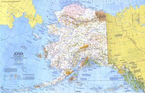
| Alaska Map 1975 |
| Item#: X NGC 061975a |
Discover Alaska's incomparable wilderness and compelling history with this informative travel map, part of the "Close-up: U.S.A" series. Half of a two-map set published in June 1975, the Alaska map highlights parks, forests, and wildlife refuges, showing both existing sites and proposed areas. Two articles accompanied this map including "Preserving America's Last Great Wilderness." The 1975 Alaska map features:
• Historical notes
• National parks, national forests, national wildlife refuges, Indian reservations, U.S. government reservations, state historic parks and monuments, state scenic and recreational parks, and recreational, scenic, or wild rivers
• Ski areas and points of interest
• Cities, towns, and abandoned or seasonally occupied settlements
• Alaska marine highway system, roads, passenger railroads, recreational trails, and airports
• Mountains, rivers, lakes, swamps, icefields and glaciers, and lava
• Native regional corporations
Coverage Area: Alaska
|
|
 |
More Product Details
This map requires 7 business days to print and laminate prior to shipping.
Appearing in the June 1975 issue of the National Geographic Magazine, this Alaska map has been reproduced from its original cartography in order to bring to life a beautiful poster previously only seen in National Geographic Magazine. This reproduction holds true to the high standards that National Geographic Maps are known for.
Perfect for home, office or classroom, this map also makes a great gift. Map collectors will surely want to add this map to their library.
The Paper version is printed on high quaility semi-gloss paper, perfect for framing.
The Laminated version uses 3mm laminate on both sides for durability, is easy to clean and markable.
From the National Geographic Classic Maps collection, this reproduction is just one of hundreds of titles available here. These maps are Printed on Demand. Sizes are approximate and may vary due to the nature of the trimming and laminating processes.
|
|
Shipping Conditions
Maps.com ships to Dometic US only
 | This product can only be shipped to the Domestic U.S.A. (No APO's or PO Boxes) |  | This map requires 2 business days to print and laminate prior to shipping. |
|
|
|
|


 Click here to zoom!