SHOP BY YEAR :: FOR OFFICE :: FOR CLASSROOM :: GIFT IDEAS :: CUSTOMER SERVICE

Western New England Map 1975
Issue: July 1975
More Views
Enlarge Image
ZoomClick here to zoom!
Purchase Product :
Please select map format:
Laminated   
22.5" x 35" - $39.95
Laminated-w/Plastic Rails  (What are rails?)
22.5" x 35" - $51.95
Paper
22.5" x 35" - $29.95
Wallzilla Adhesive Format
22.5" x 35" - $59.95
Product Highlights
Western New England Map 1975
Item#: X NGC 071975a

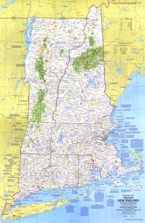
Part of the "Close-up: U.S.A." series, the Western New England map contains a wealth of notes about the festivals, events, and points of interest one can visit in this historic and scenic region. Published in July 1975 with a companion travel poster entitled "New Hampshire, Vermont, Massachusetts, Rhode Island, Connecticut: Mountains, Seacoast, and a Living Legacy," it also accompanied an article on Cape Cod.

The 1975 Western New England map features:
• Tourist activities and annual events noted
• National parks, state parks and monuments, wildlife refuges, national forests, Indian reservations, and more
• Recreational trails and recreational, scenic or wild rivers
• Capitals, cities, and towns
• Interstate highways, other roads, passenger railroads, intracoastal waterways, canals, and airports
• Subtle mountain relief, rivers, lakes, and swamps
• Ski areas

Coverage Area: New Hampshire, Vermont, Massachusetts, Rhode Island, Connecticut

More Product Details

This map requires 7 business days to print and laminate prior to shipping.

Appearing in the July 1975 issue of the National Geographic Magazine, this Western New England map has been reproduced from its original cartography in order to bring to life a beautiful poster previously only seen in National Geographic Magazine. This reproduction holds true to the high standards that National Geographic Maps are known for.

Perfect for home, office or classroom, this map also makes a great gift. Map collectors will surely want to add this map to their library.

The Paper version is printed on high quaility semi-gloss paper, perfect for framing.

The Laminated version uses 3mm laminate on both sides for durability, is easy to clean and markable.

From the National Geographic Classic Maps collection, this reproduction is just one of hundreds of titles available here. These maps are Printed on Demand. Sizes are approximate and may vary due to the nature of the trimming and laminating processes.
Shipping Conditions
Maps.com ships to Dometic US only

US FlagThis product can only be shipped to the Domestic U.S.A. (No APO's or PO Boxes)
TimeThis map requires 2 business days to print and laminate prior to shipping.