SHOP BY YEAR :: FOR OFFICE :: FOR CLASSROOM :: GIFT IDEAS :: CUSTOMER SERVICE

Ohio Valley Map 1985 Side 2
Issue: December 1985
More Views
Enlarge Image
ZoomClick here to zoom!
Purchase Product :
Please select map format:
Laminated   
27" x 20" - $39.95
Laminated-w/Plastic Rails  (What are rails?)
27" x 20" - $51.95
Paper
27" x 20" - $29.95
Wallzilla Adhesive Format
27" x 20" - $59.95
Product Highlights
Ohio Valley Map 1985 Side 2
Item#: X NGC 121985b

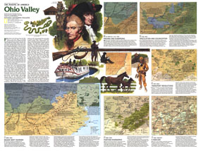
Published in December 1985, this map of the Ohio Valley represents Side Two in a two-map set in the "Making of America" series. Multiple maps illustrate the region's change from the frontier settlements of Daniel Boone and his contemporaries, to the agricultural, mining, power, and manufacturing industries of today.

The 1985 Ohio Valley map Side 2 features:
• A historical overview of the region
• Six maps detailing the history of the region with information on aboriginal cultures, speculation and colonization, Indian removal, farming, Civil War conflicts in the region, coal mining, modern industries and more
• Text about each historical period illustrated
• Colorful illustrations

Coverage Area: Kentucky, Tennessee, West Virginia, southern Ohio, southern Indiana, southern Illinois, western Virginia, eastern Missouri, northern Mississippi, northern Alabama, northern Georgia, eastern North Carolina

More Product Details

This map requires 7 business days to print and laminate prior to shipping.

Appearing in the December 1985 issue of the National Geographic Magazine, this Ohio Valley map Side 2 has been reproduced from its original cartography in order to bring to life a beautiful poster previously only seen in National Geographic Magazine. This reproduction holds true to the high standards that National Geographic Maps are known for.

Perfect for home, office or classroom, this map also makes a great gift. Map collectors will surely want to add this map to their library.

The Paper version is printed on high quaility semi-gloss paper, perfect for framing.

The Laminated version uses 3mm laminate on both sides for durability, is easy to clean and markable.

From the National Geographic Classic Maps collection, this reproduction is just one of hundreds of titles available here. These maps are Printed on Demand. Sizes are approximate and may vary due to the nature of the trimming and laminating processes.
Shipping Conditions
Maps.com ships to Dometic US only

US FlagThis product can only be shipped to the Domestic U.S.A. (No APO's or PO Boxes)
TimeThis map requires 2 business days to print and laminate prior to shipping.