SHOP BY YEAR :: FOR OFFICE :: FOR CLASSROOM :: GIFT IDEAS :: CUSTOMER SERVICE

Southeastern United States Map 1958
Issue: January 1958
More Views
Enlarge Image
ZoomClick here to zoom!
Purchase Product :
Please select map format:
Laminated   
19" x 25" - $19.95
Laminated-w/Plastic Rails  (What are rails?)
19" x 25" - $29.95
Paper
19" x 25" - $14.95
Wallzilla Adhesive Format
19" x 25" - $34.95
Product Highlights
Southeastern United States Map 1958
Item#: X NGC 011958

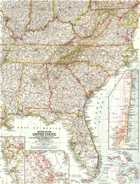
Published in January 1958, the Southeastern United States map appeared in National Geographic with three articles on Florida. Insets of the Tampa Bay, West Palm Beach and Miami regions add particular detail. Subtle mountain relief accents the Appalachians and Allegheny Mountains.

The 1958 Southeastern United States map features
• Inset of Hampton Roads, Virginia, and region
• Insets of Tampa Bay and West Palm Beach to Miami
• Capitals, cities, and towns
• Mountain relief, rivers, lakes, and swamps
• Roads, toll roads, railroads, intracoastal waterways, and places with scheduled air service
• Ocean bathymetry and the gulf stream

Coverage Area: Florida, Georgia, South Carolina, North Carolina, Virginia, West Virginia, Maryland, Kentucky, Tennessee, Mississippi, Alabama, Bahama Islands, southern Illinois, southern Indiana, southern Ohio

More Product Details

This map requires 7 business days to print and laminate prior to shipping.

Appearing in the January 1958 issue of the National Geographic Magazine, this Southeastern United States map has been reproduced from its original cartography in order to bring to life a beautiful poster previously only seen in National Geographic Magazine. This reproduction holds true to the high standards that National Geographic Maps are known for.

The Paper version is printed on high quaility semi-gloss paper, perfect for framing.

The Laminated version uses 3mm laminate on both sides for durability, is easy to clean and markable.

From the National Geographic Classic Maps collection, this reproduction is just one of hundreds of titles available here. These maps are Printed on Demand. Sizes are approximate and may vary due to the nature of the trimming and laminating processes.
Shipping Conditions
Maps.com ships to Dometic US only

US FlagThis product can only be shipped to the Domestic U.S.A. (No APO's or PO Boxes)
TimeThis map requires 2 business days to print and laminate prior to shipping.