SHOP BY YEAR :: FOR OFFICE :: FOR CLASSROOM :: GIFT IDEAS :: CUSTOMER SERVICE

Northeast, USA Map 1978
Issue: January 1978
More Views
Enlarge Image
ZoomClick here to zoom!
Purchase Product :
Please select map format:
Laminated   
35" x 22.5" - $39.95
Laminated-w/Plastic Rails  (What are rails?)
35" x 22.5" - $51.95
Paper
35" x 22.5" - $29.95
Wallzilla Adhesive Format
35" x 22.5" - $59.95
Product Highlights
Northeast, USA Map 1978
Item#: X NGC 011978a

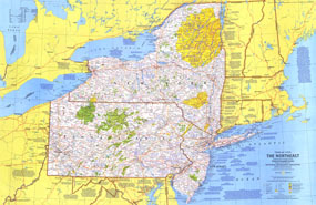
The Northeast map, published in January 1978 as part of the "Close-up: U.S.A" series, highlights the states of New York, New Jersey, and Pennsylvania. Together with its companion in the two-piece set, the travel poster "New York, New Jersey, Pennsylvania: Glittering Cities, Lonely Wild Lands," these works provide detail of the variety of exciting destinations including the cities of New York City and Philadelphia, the forests and ski resorts of the Adirondacks and Catskills, and the quaint farms of Pennsylvania Dutch country.

The 1978 Northeast, USA map features:
• Tourist activities and annual events noted
• National parks, state parks and monuments, wildlife refuges, national forests, Indian reservations, and more
• Recreational trails and recreational, scenic or wild rivers
• Capitals, cities, and towns
• Interstate highways, other roads, passenger railroads, intracoastal waterways, canals, and airports
• Mountains, rivers, lakes, and swamps
• Ski areas

Coverage Area: New York, New Jersey, Pennsylvania

More Product Details

This map requires 7 business days to print and laminate prior to shipping.

Appearing in the January 1978 issue of the National Geographic Magazine, this Northeast, USA map has been reproduced from its original cartography in order to bring to life a beautiful poster previously only seen in National Geographic Magazine. This reproduction holds true to the high standards that National Geographic Maps are known for.

The Paper version is printed on high quaility semi-gloss paper, perfect for framing.

The Laminated version uses 3mm laminate on both sides for durability, is easy to clean and markable.

From the National Geographic Classic Maps collection, this reproduction is just one of hundreds of titles available here. These maps are Printed on Demand. Sizes are approximate and may vary due to the nature of the trimming and laminating processes.
Shipping Conditions
Maps.com ships to Dometic US only

US FlagThis product can only be shipped to the Domestic U.S.A. (No APO's or PO Boxes)
TimeThis map requires 2 business days to print and laminate prior to shipping.