 |
|
|
|
|
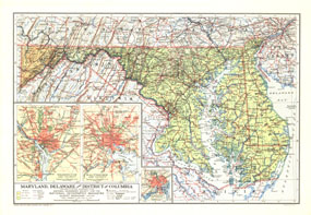
Maryland, Delaware And District Of Columbia Map 1927
Issue: February 1927
|
|
|
|
|
|
|
| Product Highlights |
| Maryland, Delaware And District Of Columbia Map 1927 |
| Item#: X NGC 021927 |
Published in February 1927, the Maryland, Delaware and District of Columbia map contains detailed insets of the cities of Baltimore, Wilmington, and Washington. The weight of type used for names gives a clue to the population of the cities at the time. The 1927 Maryland, Delaware and District of Columbia map features:
• Insets of Baltimore, Wilmington, and Washington
• State capitals, county seats, cities, and towns
• Approximate population shown by weight of type
• Important highways, railways, electric and tram lines, canals, and ferry routes
• Shading illustrating elevation
Coverage Area: Maryland, Delaware, District of Columbia
|
|
 |
More Product Details
This map requires 7 business days to print and laminate prior to shipping.
Appearing in the February 1927 issue of the National Geographic Magazine, this Maryland, Delaware And District Of Columbia map has been reproduced from its original cartography in order to bring to life a beautiful poster previously only seen in National Geographic Magazine. This reproduction holds true to the high standards that National Geographic Maps are known for.
Perfect for home, office or classroom, this map also makes a great gift. Map collectors will surely want to add this map to their library.
The Paper version is printed on high quaility semi-gloss paper, perfect for framing.
The Laminated version uses 3mm laminate on both sides for durability, is easy to clean and markable.
From the National Geographic Classic Maps collection, this reproduction is just one of hundreds of titles available here. These maps are Printed on Demand. Sizes are approximate and may vary due to the nature of the trimming and laminating processes.
|
|
Shipping Conditions
Maps.com ships to Dometic US only
 | This product can only be shipped to the Domestic U.S.A. (No APO's or PO Boxes) |  | This map requires 2 business days to print and laminate prior to shipping. |
|
|
|
|


 Click here to zoom!