SHOP BY YEAR :: FOR OFFICE :: FOR CLASSROOM :: GIFT IDEAS :: CUSTOMER SERVICE

Southeastern United States Map 1947
Issue: February 1947
More Views
Enlarge Image
ZoomClick here to zoom!
Purchase Product :
Please select map format:
Laminated   
27" x 31" - $39.95
Laminated-w/Plastic Rails  (What are rails?)
27" x 31" - $51.95
Paper
27" x 31" - $29.95
Wallzilla Adhesive Format
27" x 31" - $59.95
Product Highlights
Southeastern United States Map 1947
Item#: X NGC 021947

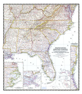
The Southeastern United States map appeared in National Geographic Magazine in February 1947. Particular attention is paid to the Atlantic coastlines with insets of the South Carolina and Georgia coasts, and Cape Hatteras and Norfolk. It also features an inset of the lower Mississippi region including New Orleans.

The 1947 Southeastern United States map features:
• Insets of Littoral of Cape Hatteras and Norfolk, the South Carolina and Georgia coasts, and the lower Mississippi
• Capitals, cities, and towns
• Mountain relief, rivers, lakes, and swamps
• U.S. highways, state highways, principal railways, canals, and intracoastal waterway
• Battlefields
• Appalachian Trail

Coverage Area: Florida, Georgia, South Carolina, North Carolina, Virginia, West Virginia, Maryland, Kentucky, Tennessee, Mississippi, Alabama, Louisiana, Bahama Islands, eastern Missouri, southern Illinois, southern Indiana, southern Ohio, northeastern Arkansas

More Product Details

This map requires 7 business days to print and laminate prior to shipping.

Appearing in the February 1947 issue of the National Geographic Magazine, this Southeastern United States map has been reproduced from its original cartography in order to bring to life a beautiful poster previously only seen in National Geographic Magazine. This reproduction holds true to the high standards that National Geographic Maps are known for.

Perfect for home, office or classroom, this map also makes a great gift. Map collectors will surely want to add this map to their library.

The Paper version is printed on high quaility semi-gloss paper, perfect for framing.

The Laminated version uses 3mm laminate on both sides for durability, is easy to clean and markable.

From the National Geographic Classic Maps collection, this reproduction is just one of hundreds of titles available here. These maps are Printed on Demand. Sizes are approximate and may vary due to the nature of the trimming and laminating processes.
Shipping Conditions
Maps.com ships to Dometic US only

US FlagThis product can only be shipped to the Domestic U.S.A. (No APO's or PO Boxes)
TimeThis map requires 2 business days to print and laminate prior to shipping.