SHOP BY YEAR :: FOR OFFICE :: FOR CLASSROOM :: GIFT IDEAS :: CUSTOMER SERVICE

New England Map 1987 Side 1
Issue: February 1987
More Views
Enlarge Image
ZoomClick here to zoom!
Purchase Product :
Please select map format:
Laminated   
20.5" x 27" - $39.95
Laminated-w/Plastic Rails  (What are rails?)
20.5" x 27" - $51.95
Paper
20.5" x 27" - $29.95
Wallzilla Adhesive Format
20.5" x 27" - $59.95
Product Highlights
New England Map 1987 Side 1
Item#: X NGC 021987a

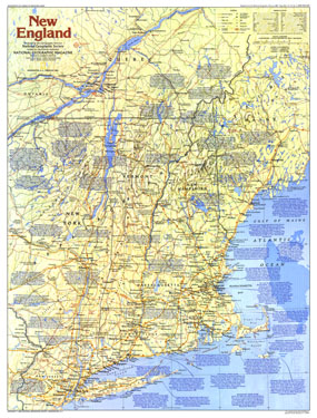
Part of the "Making of America" series and half of a two-map set, this map of New England provides a wealth of information about this historically rich region. Early Puritan settlements, battlefields of the American Revolution, and the Appalachian Trail are just some of the sites to be found here. Published in February 1987, this map and its companion accompanied the article "A Tunnel Through Time: The Appalachian Trail."

The 1987 New England map Side 1 features:
• An abundance of historical notes
• National parks, Canadian parks, battlefields, mining areas, and sites
• Capitals, cities, and towns
• Intracoastal waterways and ferry routes
• Interstate highways, major roads, other roads, passenger railroads, canals, and scheduled air service
• Mountain relief, rivers, and lakes

Coverage Area: Maine, Vermont, New Hampshire, Massachusetts, Connecticut, Rhode Island, eastern New York, northern New Jersey, southern Quebec

More Product Details

This map requires 7 business days to print and laminate prior to shipping.

Appearing in the February 1987 issue of the National Geographic Magazine, this New England map Side 1 has been reproduced from its original cartography in order to bring to life a beautiful poster previously only seen in National Geographic Magazine. This reproduction holds true to the high standards that National Geographic Maps are known for.

Perfect for home, office or classroom, this map also makes a great gift. Map collectors will surely want to add this map to their library.

The Paper version is printed on high quaility semi-gloss paper, perfect for framing.

The Laminated version uses 3mm laminate on both sides for durability, is easy to clean and markable.

From the National Geographic Classic Maps collection, this reproduction is just one of hundreds of titles available here. These maps are Printed on Demand. Sizes are approximate and may vary due to the nature of the trimming and laminating processes.
Shipping Conditions
Maps.com ships to Dometic US only

US FlagThis product can only be shipped to the Domestic U.S.A. (No APO's or PO Boxes)
TimeThis map requires 2 business days to print and laminate prior to shipping.