SHOP BY YEAR :: FOR OFFICE :: FOR CLASSROOM :: GIFT IDEAS :: CUSTOMER SERVICE

Northeastern United States Map 1959
Issue: April 1959
More Views
Enlarge Image
ZoomClick here to zoom!
Purchase Product :
Please select map format:
Laminated   
25" x 19" - $19.95
Laminated-w/Plastic Rails  (What are rails?)
25" x 19" - $29.95
Paper
25" x 19" - $14.95
Wallzilla Adhesive Format
25" x 19" - $34.95
Product Highlights
Northeastern United States Map 1959
Item#: X NGC 041959

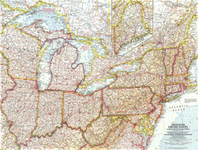
Published in April 1959, this Northeastern United States map includes the Great Lakes region and an inset of northern Maine. Additional details such as auto ferry routes and notes about the Great Lakes water levels, locks, and canals are included. The article "New Era on the Great Lakes" accompanied this detailed map.

The 1959 Northeastern United States map features:
• Inset of northern Maine
• Capitals, cities, and towns
• Freeways, roads, toll roads, railroads, canals, intracoastal waterways, auto ferry routes, and places with scheduled air service
• Ocean and Great Lakes bathymetry
• Mountains, major rivers and lakes

Coverage Area: Northeastern United States, Great Lakes

More Product Details

This map requires 7 business days to print and laminate prior to shipping.

Appearing in the April 1959 issue of the National Geographic Magazine, this Northeastern United States map has been reproduced from its original cartography in order to bring to life a beautiful poster previously only seen in National Geographic Magazine. This reproduction holds true to the high standards that National Geographic Maps are known for.

Perfect for home, office or classroom, this map also makes a great gift. Map collectors will surely want to add this map to their library.

The Paper version is printed on high quaility semi-gloss paper, perfect for framing.

The Laminated version uses 3mm laminate on both sides for durability, is easy to clean and markable.

From the National Geographic Classic Maps collection, this reproduction is just one of hundreds of titles available here. These maps are Printed on Demand. Sizes are approximate and may vary due to the nature of the trimming and laminating processes.
Shipping Conditions
Maps.com ships to Dometic US only

US FlagThis product can only be shipped to the Domestic U.S.A. (No APO's or PO Boxes)
TimeThis map requires 2 business days to print and laminate prior to shipping.