SHOP BY YEAR :: FOR OFFICE :: FOR CLASSROOM :: GIFT IDEAS :: CUSTOMER SERVICE

Northwestern United States Map 1960
Issue: April 1960
More Views
Enlarge Image
ZoomClick here to zoom!
Purchase Product :
Please select map format:
Laminated   
25" x 19" - $19.95
Laminated-w/Plastic Rails  (What are rails?)
25" x 19" - $29.95
Paper
25" x 19" - $14.95
Wallzilla Adhesive Format
25" x 19" - $34.95
Product Highlights
Northwestern United States Map 1960
Item#: X NGC 041960

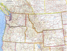
Published in April 1960, the Northwestern United States map features Washington, Oregon, Idaho, Montana, and Wyoming. This is one map in a series of six sectional maps of the United States published between 1958 and 1961. Intercontinental ballistic missile bases make it evident that this map was printed during a particularly strained period of the Cold War.

The 1960 Northeastern United States map features:
• State capitals, cities, and towns
• Railroads, roads, toll roads, freeways, and places with scheduled air service
• Mountains, rivers, lakes, intermittent lakes, dry salt lakes, deserts, lava, and glaciers
• Subtle mountain relief and ocean bathymetry
• Intercontinental ballistic missile bases
• Elevations in feet and soundings in fathoms

Coverage Area: Washington, Oregon, Idaho, Montana, Wyoming, southern British Columbia, southern Alberta, southern Saskatchewan

More Product Details

This map requires 7 business days to print and laminate prior to shipping.

Appearing in the April 1960 issue of the National Geographic Magazine, this Northwestern United States map has been reproduced from its original cartography in order to bring to life a beautiful poster previously only seen in National Geographic Magazine. This reproduction holds true to the high standards that National Geographic Maps are known for.

Perfect for home, office or classroom, this map also makes a great gift. Map collectors will surely want to add this map to their library.

The Paper version is printed on high quaility semi-gloss paper, perfect for framing.

The Laminated version uses 3mm laminate on both sides for durability, is easy to clean and markable.

From the National Geographic Classic Maps collection, this reproduction is just one of hundreds of titles available here. These maps are Printed on Demand. Sizes are approximate and may vary due to the nature of the trimming and laminating processes.
Shipping Conditions
Maps.com ships to Dometic US only

US FlagThis product can only be shipped to the Domestic U.S.A. (No APO's or PO Boxes)
TimeThis map requires 2 business days to print and laminate prior to shipping.