SHOP BY YEAR :: FOR OFFICE :: FOR CLASSROOM :: GIFT IDEAS :: CUSTOMER SERVICE

Pacific Northwest Map 1986 Side 2
Issue: August 1986
More Views
Enlarge Image
ZoomClick here to zoom!
Purchase Product :
Please select map format:
Laminated   
27" x 20" - $39.95
Laminated-w/Plastic Rails  (What are rails?)
27" x 20" - $51.95
Paper
27" x 20" - $29.95
Wallzilla Adhesive Format
27" x 20" - $59.95
Product Highlights
Pacific Northwest Map 1986 Side 2
Item#: X NGC 081986b

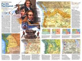
This map of the Pacific Northwest represents Side Two in a two-piece set of maps focused on this beautiful and resource-rich region. Published in August 1986 as part of the "Making of America" series, this map provides a detailed look at the history of the Pacific Northwest as it changed from tribal lands and fur trading posts to a region known for its national parks, lumber industry, dams, and resorts.

The 1986 Pacific Northwest map Side 2 features:
• A historical overview of the region
• Five maps detailing the history of the region with focuses on the tribal cultures, the fur trade, colonization, the lumber empire, railroads, mining, fisheries, agriculture, dams, recreational activities, and more
• Text about each historical period illustrated
• A map showing the transcontinental railroad systems
• Four maps showing the changes in boundaries from territories to states
• Colorful illustrations

Coverage Area: Washington, Oregon, Idaho, Montana, southern British Columbia, southern Alberta

More Product Details

This map requires 7 business days to print and laminate prior to shipping.

Appearing in the August 1986 issue of the National Geographic Magazine, this Pacific Northwest map Side 2 has been reproduced from its original cartography in order to bring to life a beautiful poster previously only seen in National Geographic Magazine. This reproduction holds true to the high standards that National Geographic Maps are known for.

Perfect for home, office or classroom, this map also makes a great gift. Map collectors will surely want to add this map to their library.

The Paper version is printed on high quaility semi-gloss paper, perfect for framing.

The Laminated version uses 3mm laminate on both sides for durability, is easy to clean and markable.

From the National Geographic Classic Maps collection, this reproduction is just one of hundreds of titles available here. These maps are Printed on Demand. Sizes are approximate and may vary due to the nature of the trimming and laminating processes.
Shipping Conditions
Maps.com ships to Dometic US only

US FlagThis product can only be shipped to the Domestic U.S.A. (No APO's or PO Boxes)
TimeThis map requires 2 business days to print and laminate prior to shipping.