SHOP BY YEAR :: FOR OFFICE :: FOR CLASSROOM :: GIFT IDEAS :: CUSTOMER SERVICE

Southwest Map 1977
Issue: October 1977
More Views
Enlarge Image
ZoomClick here to zoom!
Purchase Product :
Please select map format:
Laminated   
23" x 35" - $39.95
Laminated-w/Plastic Rails  (What are rails?)
23" x 35" - $51.95
Paper
23" x 35" - $29.95
Wallzilla Adhesive Format
23" x 35" - $59.95
Product Highlights
Southwest Map 1977
Item#: X NGC 101977a

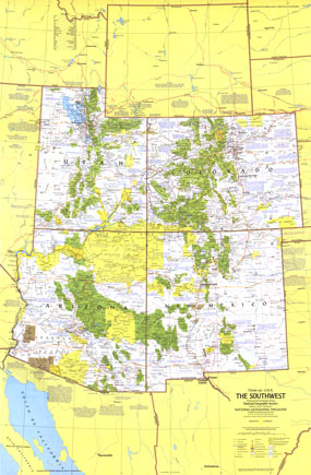
The Southwest map covers the region from the breathtaking heights of the Rocky Mountains to the otherworldly Sonoran desert of southern Arizona. Published in October 1977, this map is half of a two-piece set in the "Close-up: U.S.A." series, accompanied by the "Arizona, New Mexico, Utah, Colorado: Surprise and Challenge Amid Sere Beauty" travel poster.

The 1977 Southwest map features:
• Tourist activities and annual events noted
• National parks, state parks and monuments, wildlife refuges, state and national forests, Indian reservations, and more
• Recreational trails, routes of historic trails, and recreational, scenic or wild rivers
• Capitals, cities, and towns
• Interstate highways, other roads, passenger railroads, and airports
• Mountains, rivers, lakes, intermittent lakes, dry lakes, swamps, lava, and sand
• Ski areas and ghost towns

Coverage Area: Utah, Colorado, Arizona, New Mexico

More Product Details

This map requires 7 business days to print and laminate prior to shipping.

Appearing in the October 1977 issue of the National Geographic Magazine, this Southwest map has been reproduced from its original cartography in order to bring to life a beautiful poster previously only seen in National Geographic Magazine. This reproduction holds true to the high standards that National Geographic Maps are known for.

Perfect for home, office or classroom, this map also makes a great gift. Map collectors will surely want to add this map to their library.

The Paper version is printed on high quaility semi-gloss paper, perfect for framing.

The Laminated version uses 3mm laminate on both sides for durability, is easy to clean and markable.

From the National Geographic Classic Maps collection, this reproduction is just one of hundreds of titles available here. These maps are Printed on Demand. Sizes are approximate and may vary due to the nature of the trimming and laminating processes.
Shipping Conditions
Maps.com ships to Dometic US only

US FlagThis product can only be shipped to the Domestic U.S.A. (No APO's or PO Boxes)
TimeThis map requires 2 business days to print and laminate prior to shipping.