SHOP BY YEAR :: FOR OFFICE :: FOR CLASSROOM :: GIFT IDEAS :: CUSTOMER SERVICE

Africa Map 1980
Issue: February 1980
More Views
Enlarge Image
ZoomClick here to zoom!
Purchase Product :
Please select map format:
Laminated   
23" x 29" - $39.95
Laminated-w/Plastic Rails  (What are rails?)
23" x 29" - $51.95
Paper
23" x 29" - $29.95
Wallzilla Adhesive Format
23" x 29" - $59.95
Product Highlights
Africa Map 1980
Item#: X NGC 021980a

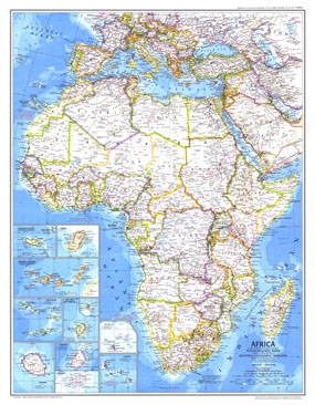
This classic Africa map is a perfect combination of exceptional cartography and rich detail. Published in February of 1980, this map accompanied an excellent overview called "Africa, Its Political Development." Together, these maps provided both historical and modern pictures of this incredible continent.

The 1980 Africa map features:
• Country boundaries that show the countries of Africa, as well as European and Asian countries surrounding the Mediterranean
• Thousands of place names, including capitals, ports, deserts, ruins, and much more
• Roads, railroads, airports canals
• Oil pipelines and oil fields
• Tinting around the coastline to show ocean depths
• Insets for the Madeira Islands, Bioko, Canary Islands, Cape Verde, Sao Tome and Principe, Reunion, Mauritius, Rodrigues, Seychelles, and Comoros

Coverage Area: Africa, Madeira Islands, Bioko, Canary Islands, Cape Verde, Sao Tome and Principe, Reunion, Mauritius, Rodrigues, Seychelles, Comoros, European and Asian countries surrounding the Mediterranean

More Product Details

This map requires 7 business days to print and laminate prior to shipping.

Appearing in the February 1980 issue of the National Geographic Magazine, this Africa map has been reproduced from its original cartography in order to bring to life a beautiful poster previously only seen in National Geographic Magazine. This reproduction holds true to the high standards that National Geographic Maps are known for.

Perfect for home, office or classroom, this map also makes a great gift. Map collectors will surely want to add this map to their library.

The Paper version is printed on high quaility semi-gloss paper, perfect for framing.

The Laminated version uses 3mm laminate on both sides for durability, is easy to clean and markable.

From the National Geographic Classic Maps collection, this reproduction is just one of hundreds of titles available here. These maps are Printed on Demand. Sizes are approximate and may vary due to the nature of the trimming and laminating processes.
Shipping Conditions
Maps.com ships to Dometic US only

US FlagThis product can only be shipped to the Domestic U.S.A. (No APO's or PO Boxes)
TimeThis map requires 2 business days to print and laminate prior to shipping.