SHOP BY YEAR :: FOR OFFICE :: FOR CLASSROOM :: GIFT IDEAS :: CUSTOMER SERVICE

Africa Map 1960
Issue: September 1960
More Views
Enlarge Image
ZoomClick here to zoom!
Purchase Product :
Please select map format:
Laminated   
19" x 25" - $19.95
Laminated-w/Plastic Rails  (What are rails?)
19" x 25" - $29.95
Paper
19" x 25" - $14.95
Wallzilla Adhesive Format
19" x 25" - $34.95
Product Highlights
Africa Map 1960
Item#: X NGC 091960a

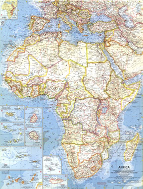
Africa would undergo many changes in the 1960s with many nations struggling and winning their independence. Published in September 1960 with three articles including "Africa: The Winds of Freedom Stir a Continent," this map shows the country boundaries as they existed on July 15, 1960 when the map went to press.

The 1960 Africa map features:
• Inset maps of islands including the Azores, Canary Islands, Cape Verde Islands, La Reunion, Madeira Islands, Maurituis Island, Seychelles, and Socotra (Suqutra)
• Map of the Great Rift Valley
• Thousands of place names including capitals, cities, and towns
• Ocean bathymetry and currents
• Geographical features including mountains, rivers, lakes, deserts, volcanic debris, and areas below sea level
• Railroads, roads, and places with scheduled air service
• Ruins, oil fields, and oil pipelines

Coverage Area: Africa, southern Europe, western Asia

More Product Details

This map requires 7 business days to print and laminate prior to shipping.

Appearing in the September 1960 issue of the National Geographic Magazine, this Africa map has been reproduced from its original cartography in order to bring to life a beautiful poster previously only seen in National Geographic Magazine. This reproduction holds true to the high standards that National Geographic Maps are known for.

Perfect for home, office or classroom, this map also makes a great gift. Map collectors will surely want to add this map to their library.

The Paper version is printed on high quaility semi-gloss paper, perfect for framing.

The Laminated version uses 3mm laminate on both sides for durability, is easy to clean and markable.

From the National Geographic Classic Maps collection, this reproduction is just one of hundreds of titles available here. These maps are Printed on Demand. Sizes are approximate and may vary due to the nature of the trimming and laminating processes.
Shipping Conditions
Maps.com ships to Dometic US only

US FlagThis product can only be shipped to the Domestic U.S.A. (No APO's or PO Boxes)
TimeThis map requires 2 business days to print and laminate prior to shipping.