SHOP BY YEAR :: FOR OFFICE :: FOR CLASSROOM :: GIFT IDEAS :: CUSTOMER SERVICE

Africa Map 1922 with portions of Europe and Asia
Issue: October 1922
More Views
Enlarge Image
ZoomClick here to zoom!
Purchase Product :
Please select map format:
Laminated   
28.5" x 31.5" - $39.95
Laminated-w/Plastic Rails  (What are rails?)
28.5" x 31.5" - $51.95
Paper
28.5" x 31.5" - $29.95
Wallzilla Adhesive Format
28.5" x 31.5" - $59.95
Product Highlights
Africa Map 1922 with portions of Europe and Asia
Item#: X NGC 101922

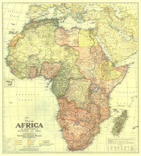
In October 1922, National Geographic devoted an entire issue to the continent of Africa which included this beautifully crafted map. Discover Africa in the early 20th century when transportation on the continent was in its infancy and many rivers were yet unexplored.

The 1922 Africa map with adjoining portions of Europe and Asia features:
• Countries are colored according to colonial administration, showing the Independent countries as well as administration by Britain, France, Portugal, Belgium, Spain, and Italy
• A key to assist English speakers with pronunciations of French, Italian, and Portugeuse names, as well as a translation key for native words
• Capital cities and towns
• Caravan routes and railroads, both finished and proposed
• Rivers, unexplored rivers, intermittant streams, swamps and falls or rapids are noted
• Desert areas clearly indicated
• Inset of the Cape Verde Islands

Coverage Area: Africa, Arabia, Persia, Syria, Kingdom of Iraq, Turkey, Greece, Italy, Spain

More Product Details

This map requires 7 business days to print and laminate prior to shipping.

Appearing in the October 1922 issue of the National Geographic Magazine, this Africa map with adjoining portions of Europe and Asia has been reproduced from its original cartography in order to bring to life a beautiful poster previously only seen in National Geographic Magazine. This reproduction holds true to the high standards that National Geographic Maps are known for.

Perfect for home, office or classroom, this map also makes a great gift. Map collectors will surely want to add this map to their library.

The Paper version is printed on high quaility semi-gloss paper, perfect for framing.

The Laminated version uses 3mm laminate on both sides for durability, is easy to clean and markable.

From the National Geographic Classic Maps collection, this reproduction is just one of hundreds of titles available here. These maps are Printed on Demand. Sizes are approximate and may vary due to the nature of the trimming and laminating processes.
Shipping Conditions
Maps.com ships to Dometic US only

US FlagThis product can only be shipped to the Domestic U.S.A. (No APO's or PO Boxes)
TimeThis map requires 2 business days to print and laminate prior to shipping.