 |
|
|
|
|
Southern Africa Map 1962
Issue: November 1962
|
|
|
|
|
|
|
| Product Highlights |
| Southern Africa Map 1962 |
| Item#: X NGC 111962 |
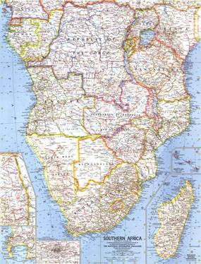
Published in November 1962, this map of Southern Africa appeared in National Geographic with three articles including "South Africa Close-up." South Africa had just become a republic the year before and the struggle against apartheid had begun. Nelson Mandela was arrested and imprisoned just months before this map was printed. The 1962 Southern Africa map features:
• Inset maps of the Malagasy Republic (Madagascar) and the Comoro Islands
• National parks including an inset map of Kruger National Park in South Africa
• City maps of Johannesburg and Cape Town
• Thousands of place names including capitals, cities and towns
• Railroads, roads, trails, canals, and places with scheduled air service
• Ocean bathymetry and geographical features including mountains, rivers, lakes, dry salt lakes, and deserts
Coverage Area: Southern Africa
|
|
 |
More Product Details
This map requires 7 business days to print and laminate prior to shipping.
Appearing in the November 1962 issue of the National Geographic Magazine, this Southern Africa map has been reproduced from its original cartography in order to bring to life a beautiful poster previously only seen in National Geographic Magazine. This reproduction holds true to the high standards that National Geographic Maps are known for.
Perfect for home, office or classroom, this map also makes a great gift. Map collectors will surely want to add this map to their library.
The Paper version is printed on high quaility semi-gloss paper, perfect for framing.
The Laminated version uses 3mm laminate on both sides for durability, is easy to clean and markable.
From the National Geographic Classic Maps collection, this reproduction is just one of hundreds of titles available here. These maps are Printed on Demand. Sizes are approximate and may vary due to the nature of the trimming and laminating processes.
|
|
Shipping Conditions
Maps.com ships to Dometic US only
 | This product can only be shipped to the Domestic U.S.A. (No APO's or PO Boxes) |  | This map requires 2 business days to print and laminate prior to shipping. |
|
|
|
|


 Click here to zoom!