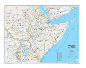
This Horn of Africa Wall Map by National Geographic contains extensive political information with political boundaries clearly presented with different color-bands for each country. Beautifully shaded to show both land and water features. View in detail the interesting juxtaposition of Africa to the Arabian Peninsula, or how narrow the crossing from the Gulf of Aden to the Red Sea can be.
This region is often in news for all the wrong reasons; famine, war, and humanitarian struggles. But the USA and UN have pledged millions of dollars in aid to help put an end to the suffering.
Details featured on this wall map of the Horn of Africa include:
• Political Boundaries
• Major Cities and Capitals
• Physical Terrain Shading
• Mountain Ranges, Highest Point
• Lakes, Seas, Rivers and Waterways
• Sand, Swamp, Salt Desert, Dry Salt Lake or Coral Reef
• Latitude and Longitude Lines
• Basic Bathymetry (Ocean Depths)
• Major Airports
• National Parks
• Major Roads and Highways
• Oil Fields, Railroads, and Ruins
|


 Click here to zoom!
