 |
|
|
|
|
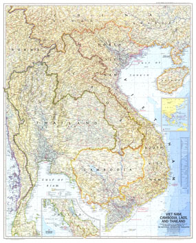
Vietnam, Cambodia, Laos, And Thailand Map 1967
Issue: February 1967
|
|
|
|
|
|
|
| Product Highlights |
| Vietnam, Cambodia, Laos, And Thailand Map 1967 |
| Item#: X NGC 021967 |
Published in February 1967 with the article "Behind the Headlines in Viet Nam," this map demonstrates the cartographic excellence that National Geographic is known for. Map collectors and those interested in the Viet Nam War era will enjoy this detailed, historical piece. A great companion to the map of the same region published in 1965. The 1967 Viet Nam, Cambodia, Laos, and Thailand map features:
• Inset of the Continuation of Thailand
• Location map inset
• Relief shown by light and shadow as if from sun low in the northwest
• Geographical equivalents
• Railroads and roads (both existing and under construction), route numbers, tracks and trails, airfields, and canals
• Warm currents and channel depths for principal ports
• Rice fields, swamps, rivers, and lakes
Coverage Area: Viet Nam, Cambodia, Laos, and Thailand (Siam)
|
|
 |
More Product Details
This map requires 7 business days to print and laminate prior to shipping.
Appearing in the February 1967 issue of the National Geographic Magazine, this Vietnam, Cambodia, Laos, And Thailand map has been reproduced from its original cartography in order to bring to life a beautiful poster previously only seen in National Geographic Magazine. This reproduction holds true to the high standards that National Geographic Maps are known for.
Perfect for home, office or classroom, this map also makes a great gift. Map collectors will surely want to add this map to their library.
The Paper version is printed on high quaility semi-gloss paper, perfect for framing.
The Laminated version uses 3mm laminate on both sides for durability, is easy to clean and markable.
From the National Geographic Classic Maps collection, this reproduction is just one of hundreds of titles available here. These maps are Printed on Demand. Sizes are approximate and may vary due to the nature of the trimming and laminating processes.
|
|
Shipping Conditions
Maps.com ships to Dometic US only
 | This product can only be shipped to the Domestic U.S.A. (No APO's or PO Boxes) |  | This map requires 2 business days to print and laminate prior to shipping. |
|
|
|
|


 Click here to zoom!