SHOP BY YEAR :: FOR OFFICE :: FOR CLASSROOM :: GIFT IDEAS :: CUSTOMER SERVICE

Indonesia Map 1996 Side 2
Issue: February 1996
More Views
Enlarge Image
ZoomClick here to zoom!
Purchase Product :
Please select map format:
Laminated   
31" x 20" - $39.95
Laminated-w/Plastic Rails  (What are rails?)
31" x 20" - $51.95
Paper
31" x 20" - $29.95
Wallzilla Adhesive Format
31" x 20" - $59.95
Product Highlights
Indonesia Map 1996 Side 2
Item#: X NGC 021996b

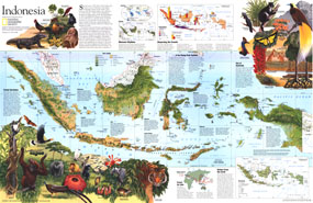
Explore a fascinating land of unique animal species, the world's largest flower, and butterflies with foot-wide wingspans, with this beautiful and educational map of Indonesia. Half of a two-map set published in February 1996, this map was also accompanied by an article on Irian Jaya, the largest and least developed of Indonesia's 27 provinces.

The 1996 Indonesia map side 2 features:
• Inset maps showing climate, rainfall, and population
• Maps and information about the timber industry, oil and gas production, mining, and other economic resources
• Beautiful illustrations of the flora and fauna of Indonesia, including some of the most unique animals in the world
• An abundance of information on the geography and wildlife of the region
• Wallace's Line which is the break between the Australian and Asian animal kingdoms
• Geographical details include mangrove, rainforests, grasslands, cultivated or inhabited areas, coral reefs, protected areas, volcanos and more
• Airports

Coverage Area: Indonesia, Malaysia, Brunei

More Product Details

This map requires 7 business days to print and laminate prior to shipping.

Appearing in the February 1996 issue of the National Geographic Magazine, this Indonesia map has been reproduced from its original cartography in order to bring to life a beautiful poster previously only seen in National Geographic Magazine. This reproduction holds true to the high standards that National Geographic Maps are known for.

Perfect for home, office or classroom, this map also makes a great gift. Map collectors will surely want to add this map to their library.

The Paper version is printed on high quaility semi-gloss paper, perfect for framing.

The Laminated version uses 3mm laminate on both sides for durability, is easy to clean and markable.

From the National Geographic Classic Maps collection, this reproduction is just one of hundreds of titles available here. These maps are Printed on Demand. Sizes are approximate and may vary due to the nature of the trimming and laminating processes.
Shipping Conditions
Maps.com ships to Dometic US only

US FlagThis product can only be shipped to the Domestic U.S.A. (No APO's or PO Boxes)
TimeThis map requires 2 business days to print and laminate prior to shipping.