 |
|
|
|
|
Soviet Union Map 1990 SIde 2
Issue: March 1990
|
|
|
|
|
|
|
| Product Highlights |
| Soviet Union Map 1990 SIde 2 |
| Item#: X NGC 031990b |
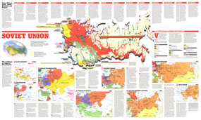
This map of the Soviet Union contains a total of nine individual maps featuring an abundance of historical information about the enormous federation of countries and their diverse peoples. Published in March 1990 as half of a two-map set, these works appeared only twenty-one months before the dismantling of the Soviet Union. This map represents Side Two of the set. The 1990 Soviet Union map Side 2 features:
• Ethnolinguistic groups of the Soviet Union
• Information on the Soviet Republics and their people
• Maps detailing the early history of the region including Slavic Expansion (ca 600), the Kievan Rus (1054), Seeds of the Russian State (1380), and the Tsardom of Muscovy (1596)
• Two maps showing historical activity in the 19th century including the Westward Inroads (1815) and the Long Movement Eastward which details Russia's acquisitions through 1886
• A War and Revolution map of 1914 showing the Jewish Pale, settlements, railroads, textiles, industrial centers, and more
• A Soviet Sphere map of 1955 which shows Soviet annexations, the farthest extent of German penetration in World War II, and more
Coverage Area: Soviet Union
|
|
 |
More Product Details
This map requires 7 business days to print and laminate prior to shipping.
Appearing in the March 1990 issue of the National Geographic Magazine, this Soviet Union map has been reproduced from its original cartography in order to bring to life a beautiful poster previously only seen in National Geographic Magazine. This reproduction holds true to the high standards that National Geographic Maps are known for.
Perfect for home, office or classroom, this map also makes a great gift. Map collectors will surely want to add this map to their library.
The Paper version is printed on high quaility semi-gloss paper, perfect for framing.
The Laminated version uses 3mm laminate on both sides for durability, is easy to clean and markable.
From the National Geographic Classic Maps collection, this reproduction is just one of hundreds of titles available here. These maps are Printed on Demand. Sizes are approximate and may vary due to the nature of the trimming and laminating processes.
|
|
Shipping Conditions
Maps.com ships to Dometic US only
 | This product can only be shipped to the Domestic U.S.A. (No APO's or PO Boxes) |  | This map requires 2 business days to print and laminate prior to shipping. |
|
|
|
|


 Click here to zoom!