 |
|
|
|
|
The Far East Map 1952
Issue: September 1952
|
|
|
|
|
|
|
| Product Highlights |
| The Far East Map 1952 |
| Item#: X NGC 091952a |
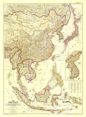
In the Far East in early 1950s, two wars raged: the Korean War and the First Indochina War. This map of the region, published in September 1952 with the article "Indochina Faces the Dragon," includes an inset map of Korea with the battle line noted as of July of that year. The 1952 Far East map features:
• Detailed inset map of Korea including the battle line of July 1, 1952
• Historical notes
• Thousands of cities and towns, including capitals
• Mountains, rivers, lakes, deserts, water holes, and more
• Principal railroads, roads, canals, and principal airports
• The Great Wall of China and ruins
• Oil fields and pipelines
Coverage Area: Eastern Asia
|
|
 |
More Product Details
This map requires 7 business days to print and laminate prior to shipping.
Appearing in the September 1952 issue of the National Geographic Magazine, this The Far East map has been reproduced from its original cartography in order to bring to life a beautiful poster previously only seen in National Geographic Magazine. This reproduction holds true to the high standards that National Geographic Maps are known for.
Perfect for home, office or classroom, this map also makes a great gift. Map collectors will surely want to add this map to their library.
The Paper version is printed on high quaility semi-gloss paper, perfect for framing.
The Laminated version uses 3mm laminate on both sides for durability, is easy to clean and markable.
From the National Geographic Classic Maps collection, this reproduction is just one of hundreds of titles available here. These maps are Printed on Demand. Sizes are approximate and may vary due to the nature of the trimming and laminating processes.
|
|
Shipping Conditions
Maps.com ships to Dometic US only
 | This product can only be shipped to the Domestic U.S.A. (No APO's or PO Boxes) |  | This map requires 2 business days to print and laminate prior to shipping. |
|
|
|
|


 Click here to zoom!