SHOP BY YEAR :: FOR OFFICE :: FOR CLASSROOM :: GIFT IDEAS :: CUSTOMER SERVICE

Asia-Pacific Map 1989
Issue: November 1989
More Views
Enlarge Image
ZoomClick here to zoom!
Purchase Product :
Please select map format:
Laminated   
19.5" x 25" - $19.95
Laminated-w/Plastic Rails  (What are rails?)
19.5" x 25" - $29.95
Paper
19.5" x 25" - $14.95
Wallzilla Adhesive Format
19.5" x 25" - $34.95
Product Highlights
Asia-Pacific Map 1989
Item#: X NGC 111989a

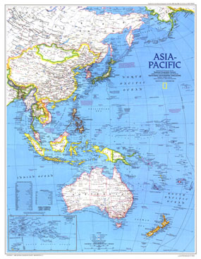
This vibrant map of the Asia-Pacific region provides detail of eastern Asia, Australia and New Zealand as well as the thousands of islands in the Pacific. Published in November 1989, the Asia-Pacific map accompanied four articles on the region including "Hanoi: The Capital Today." The Western Pacific Rim map was also published in the same issue as a companion supplement to this map.

The 1989 Asia-Pacific map features:
• Continuation of main map inset showing French Polynesia and surrounding islands
• Thousands of place names including capitals, cities, and towns
• Roads, railroads, and selected air service
• Colorful, clearly defined country borders
• Geographical Equivalents and abbreviations
• Coral reefs, rivers, lakes, and dry salt lakes
• Oil pipelines and oil fields

Coverage Area: Eastern Asia, Aleutian Islands, Indonesia, Philippines, Pacific Islands, Australia, New Zealand

More Product Details

This map requires 7 business days to print and laminate prior to shipping.

Appearing in the November 1989 issue of the National Geographic Magazine, this Asia-Pacific map has been reproduced from its original cartography in order to bring to life a beautiful poster previously only seen in National Geographic Magazine. This reproduction holds true to the high standards that National Geographic Maps are known for.

Perfect for home, office or classroom, this map also makes a great gift. Map collectors will surely want to add this map to their library.

The Paper version is printed on high quaility semi-gloss paper, perfect for framing.

The Laminated version uses 3mm laminate on both sides for durability, is easy to clean and markable.

From the National Geographic Classic Maps collection, this reproduction is just one of hundreds of titles available here. These maps are Printed on Demand. Sizes are approximate and may vary due to the nature of the trimming and laminating processes.
Shipping Conditions
Maps.com ships to Dometic US only

US FlagThis product can only be shipped to the Domestic U.S.A. (No APO's or PO Boxes)
TimeThis map requires 2 business days to print and laminate prior to shipping.