|
|
Australia Continental Odyssey Map 1988
Issue: February 1988

|
|
|
|
|
|
|
| Product Highlights |
| Australia Continental Odyssey Map 1988 |
| Item#: X NGC 021988b |
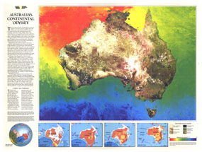
This unique map is a photomosaic of computer-enhanced satellite images portraying Australia's physical features and vegetation. A brief history of the continent's formation is included as well as a colorful demonstration of the temperature gradient of the region. This map was published in February 1988 in an issue devoted to Australia's bicentennial which included another map, "A Traveler's Look at Australia." Together, the two maps make fine keepsakes for those interested in "The Land Down Under." The 1988 "Australia Continental Odyssey" map features:
• Illustration showing Australia's position 200 million years ago
• Inset maps showing Australia's growth and movement from 125 million years ago to present day
• Information on the formation of the continent
• Computer-enhanced satellite image showing vegetation
• A colorful temperature gradient of the continent
Coverage Area: Australia
|
|
More Product Details
This map requires 7 business days to print and laminate prior to shipping.
Appearing in the February 1988 issue of the National Geographic Magazine, this Australia Continental Odyssey map has been reproduced from its original cartography in order to bring to life a beautiful poster previously only seen in National Geographic Magazine. This reproduction holds true to the high standards that National Geographic Maps are known for.
Perfect for home, office or classroom, this map also makes a great gift. Map collectors will surely want to add this map to their library.
The Paper version is printed on high quaility semi-gloss paper, perfect for framing.
The Laminated version uses 3mm laminate on both sides for durability, is easy to clean and markable.
From the National Geographic Classic Maps collection, this reproduction is just one of hundreds of titles available here. These maps are Printed on Demand. Sizes are approximate and may vary due to the nature of the trimming and laminating processes.
|
|
Shipping Conditions
Maps.com ships to Dometic US only
 | This product can only be shipped to the Domestic U.S.A. (No APO's or PO Boxes) |  | This map requires 2 business days to print and laminate prior to shipping. |
|


 Click here to zoom!