SHOP BY YEAR :: FOR OFFICE :: FOR CLASSROOM :: GIFT IDEAS :: CUSTOMER SERVICE

Discoverers Of The Pacific Map 1974
Issue: December 1974
More Views
Enlarge Image
ZoomClick here to zoom!
Purchase Product :
Please select map format:
Laminated   
37" x 22.5" - $59.95
Laminated-w/Plastic Rails  (What are rails?)
37" x 22.5" - $76.95
Paper
37" x 22.5" - $49.95
Wallzilla Adhesive Format
37" x 22.5" - $89.95
Product Highlights
Discoverers Of The Pacific Map 1974
Item#: X NGC 121974b

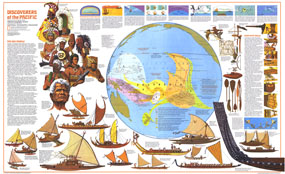
The Discoverers of the Pacific map was published in December 1974 as half of a two-map set with the Islands of the Pacific map and the article "The Coming of the Polynesians." An educational work, this map contains an abundance of information about Pacific Islanders, their shipbuilding techniques, types of canoes, and how they navigated using the stars, birds, and other natural data.

The 1974 Discoverers of the Pacific map features:
• A map showing the travels of Pacific Islanders and how various islands were discovered
• Information on Pacific Islanders, their history, and their extraordinary sea-faring abilities
• Illustrations and information on the canoe-building practices of Pacific Islanders
• Illustrations and information about many types of canoes
• "Steering by Stars and Sea" article with illustrations to show how islanders navigated
• Illustrations of various peoples who inhabited the Pacific
• Illustrations of native shipbuilding tools

Coverage Area: South Pacific, Indonesia, Micronesia, New Guinea, Solomon Islands, Polynesia, Hawaiian Islands, New Zealand, Australia

More Product Details

This map requires 7 business days to print and laminate prior to shipping.

Appearing in the December 1974 issue of the National Geographic Magazine, this Discoverers Of The Pacific map has been reproduced from its original cartography in order to bring to life a beautiful poster previously only seen in National Geographic Magazine. This reproduction holds true to the high standards that National Geographic Maps are known for.

Perfect for home, office or classroom, this map also makes a great gift. Map collectors will surely want to add this map to their library.

The Paper version is printed on high quaility semi-gloss paper, perfect for framing.

The Laminated version uses 3mm laminate on both sides for durability, is easy to clean and markable.

From the National Geographic Classic Maps collection, this reproduction is just one of hundreds of titles available here. These maps are Printed on Demand. Sizes are approximate and may vary due to the nature of the trimming and laminating processes.
Shipping Conditions
Maps.com ships to Dometic US only

US FlagThis product can only be shipped to the Domestic U.S.A. (No APO's or PO Boxes)
TimeThis map requires 2 business days to print and laminate prior to shipping.