SHOP BY YEAR :: FOR OFFICE :: FOR CLASSROOM :: GIFT IDEAS :: CUSTOMER SERVICE

Top Of The World Map 1949
Issue: October 1949
More Views
Enlarge Image
ZoomClick here to zoom!
Purchase Product :
Please select map format:
Laminated   
28" x 29" - $39.95
Laminated-w/Plastic Rails  (What are rails?)
28" x 29" - $51.95
Paper
28" x 29" - $29.95
Wallzilla Adhesive Format
28" x 29" - $59.95
Product Highlights
Top Of The World Map 1949
Item#: X NGC 101949

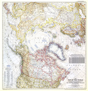
In the October 1949 issue of National Geographic, there were five articles related to polar exploration. The Top of the World map, first published in October of 1949, offers a truly unique view that features the Arctic Polar Region at its center. This beautiful map is both a cartographic masterpiece and a fresh look at the world.

The 1949 Top of the World map features:
• View of the top of the world with the North Polar region at its center
• Beautiful cartograhy that highlights international boundaries, peppered with thousands of place names
• Ocean currents in the northermost regions of the world
• Descriptions of polar expeditions by Peary, Byrd, Ellsworht, Amundsen, Nobile, and Schmidt
• Principal railways, important airports, canals, Arctic roads and trails, and passes
• Delineations for permanent polar ice, glaciers, areas below sea level, and dry salt lakes
• Airline distances between major cities on the map

Coverage Area: Arctic polar region, northern US, Canada, northern Europe, northern USSR

More Product Details

This map requires 7 business days to print and laminate prior to shipping.

Appearing in the October 1949 issue of the National Geographic Magazine, this Top Of The World map has been reproduced from its original cartography in order to bring to life a beautiful poster previously only seen in National Geographic Magazine. This reproduction holds true to the high standards that National Geographic Maps are known for.

Perfect for home, office or classroom, this map also makes a great gift. Map collectors will surely want to add this map to their library.

The Paper version is printed on high quaility semi-gloss paper, perfect for framing.

The Laminated version uses 3mm laminate on both sides for durability, is easy to clean and markable.

From the National Geographic Classic Maps collection, this reproduction is just one of hundreds of titles available here. These maps are Printed on Demand. Sizes are approximate and may vary due to the nature of the trimming and laminating processes.
Shipping Conditions
Maps.com ships to Dometic US only

US FlagThis product can only be shipped to the Domestic U.S.A. (No APO's or PO Boxes)
TimeThis map requires 2 business days to print and laminate prior to shipping.