SHOP BY YEAR :: FOR OFFICE :: FOR CLASSROOM :: GIFT IDEAS :: CUSTOMER SERVICE

Arctic Regions Map 1925
Issue: November 1925
More Views
Enlarge Image
ZoomClick here to zoom!
Purchase Product :
Please select map format:
Laminated   
20" x 19" - $19.95
Laminated-w/Plastic Rails  (What are rails?)
20" x 19" - $29.95
Paper
20" x 19" - $14.95
Wallzilla Adhesive Format
20" x 19" - $34.95
Product Highlights
Arctic Regions Map 1925
Item#: X NGC 111925

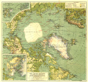
This bold map of the Arctic regions appeared in National Geographic Magazine in November of 1925 with the article "The MacMillan Arctic Expedition Returns." In this article, the world would discover the man who would soon be the most famous aviator-explorer of the era: Richard E. Byrd. Filled with detailed explorers routes, this is a wonderful companion to the North Pole Regions map of 1907.

The 1925 Arctic Regions map features:
• Detailed insets of the Ellesmere Island region, Spitsbergen, and Franz Josef Land
• Routes of explorers including flights of US Navy planes in the MacMillan Arctic Expedition, 1925
• Warm and cold ocean currents and courses of icebergs
• Land elevation indicated by color
• Glaciers and ice caps
• Railways

Coverage Area: Arctic polar region, Alaska, northern Canada, northern Russia, Greenland, Spitzbergen and Franz Josef Land, Sweden, Norway, and Finland

More Product Details

This map requires 7 business days to print and laminate prior to shipping.

Appearing in the November 1925 issue of the National Geographic Magazine, this Arctic Regions map has been reproduced from its original cartography in order to bring to life a beautiful poster previously only seen in National Geographic Magazine. This reproduction holds true to the high standards that National Geographic Maps are known for.

Perfect for home, office or classroom, this map also makes a great gift. Map collectors will surely want to add this map to their library.

The Paper version is printed on high quaility semi-gloss paper, perfect for framing.

The Laminated version uses 3mm laminate on both sides for durability, is easy to clean and markable.

From the National Geographic Classic Maps collection, this reproduction is just one of hundreds of titles available here. These maps are Printed on Demand. Sizes are approximate and may vary due to the nature of the trimming and laminating processes.
Shipping Conditions
Maps.com ships to Dometic US only

US FlagThis product can only be shipped to the Domestic U.S.A. (No APO's or PO Boxes)
TimeThis map requires 2 business days to print and laminate prior to shipping.