SHOP BY YEAR :: FOR OFFICE :: FOR CLASSROOM :: GIFT IDEAS :: CUSTOMER SERVICE

Top Of The World Map 1969
Issue: November 1965
More Views
Enlarge Image
ZoomClick here to zoom!
Purchase Product :
Please select map format:
Laminated   
25" x 19" - $19.95
Laminated-w/Plastic Rails  (What are rails?)
25" x 19" - $29.95
Paper
25" x 19" - $14.95
Wallzilla Adhesive Format
25" x 19" - $34.95
Product Highlights
Top Of The World Map 1969
Item#: X NGC 111965

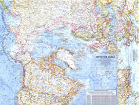
In the mid 1960s, the USSR and US were in the midst of a cold war in which each nation was acutely aware of its proximity to the other. The Top of the World map, published in November of 1965, offers a truly unique view that features the Arctic Polar Region at its center. Shown on this map are the "Early Warning Lines" in case of imminent nuclear attack from the USSR. This beautiful map is both a cartographic and historical masterpiece. Dazzling cartography and attention to detail make this a real collectors edition.

The 1965 Top of the World map features:
• View of the top of the world with the North Polar region at its center
• Beautiful cartograhy that highlights international boundaries, peppered with thousands of place names
• Detailed ocean currents in the northermost regions of the world
• An inset showing the relation of North America to Europe and the Middle East
• Principal railways, important airports, canals, Arctic roads and trails, and passes
• Early Warning Lines in case of imminent nuclear attack on the US by the USSR
• Airline distances between major cities on the map

Coverage Area: Arctic polar region, northern US, Canada, northern Europe, northern USSR

More Product Details

This map requires 7 business days to print and laminate prior to shipping.

Appearing in the November 1965 issue of the National Geographic Magazine, this Top Of The World map has been reproduced from its original cartography in order to bring to life a beautiful poster previously only seen in National Geographic Magazine. This reproduction holds true to the high standards that National Geographic Maps are known for.

Perfect for home, office or classroom, this map also makes a great gift. Map collectors will surely want to add this map to their library.

The Paper version is printed on high quaility semi-gloss paper, perfect for framing.

The Laminated version uses 3mm laminate on both sides for durability, is easy to clean and markable.

From the National Geographic Classic Maps collection, this reproduction is just one of hundreds of titles available here. These maps are Printed on Demand. Sizes are approximate and may vary due to the nature of the trimming and laminating processes.
Shipping Conditions
Maps.com ships to Dometic US only

US FlagThis product can only be shipped to the Domestic U.S.A. (No APO's or PO Boxes)
TimeThis map requires 2 business days to print and laminate prior to shipping.