 |
|
|
|
|
Europe And The Mediterranean Map 1938
Issue: April 1938
|
|
|
|
|
|
|
| Product Highlights |
| Europe And The Mediterranean Map 1938 |
| Item#: X NGC 041938 |
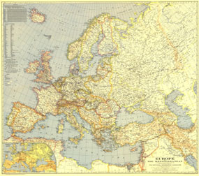
Published in April 1938, this map of Europe and the Mediterranean is a snapshot of the region prior to World War II. A unique feature of this map and others of its era is the list of country names in English as well as the national language. The 1938 Europe and the Mediterranean map features:
• Distances between European ports and other important world ports via the shortest navigable routes
• List of the English names for countries and their names in the national language
• Inset relief map with airways
• Capitals, cities, and towns
• Canals, and railroads, including through routes, connecting lines, and railroads under construction
• Moutains, passes, rivers, lakes, glaciers, and swampy regions
• Ruins
Coverage Area: Europe, Mediterranean coasts of Africa and Asia
|
|
 |
More Product Details
This map requires 7 business days to print and laminate prior to shipping.
Appearing in the April 1938 issue of the National Geographic Magazine, this Europe And The Mediterranean map has been reproduced from its original cartography in order to bring to life a beautiful poster previously only seen in National Geographic Magazine. This reproduction holds true to the high standards that National Geographic Maps are known for.
Perfect for home, office or classroom, this map also makes a great gift. Map collectors will surely want to add this map to their library.
The Paper version is printed on high quaility semi-gloss paper, perfect for framing.
The Laminated version uses 3mm laminate on both sides for durability, is easy to clean and markable.
From the National Geographic Classic Maps collection, this reproduction is just one of hundreds of titles available here. These maps are Printed on Demand. Sizes are approximate and may vary due to the nature of the trimming and laminating processes.
|
|
Shipping Conditions
Maps.com ships to Dometic US only
 | This product can only be shipped to the Domestic U.S.A. (No APO's or PO Boxes) |  | This map requires 2 business days to print and laminate prior to shipping. |
|
|
|
|


 Click here to zoom!