SHOP BY YEAR :: FOR OFFICE :: FOR CLASSROOM :: GIFT IDEAS :: CUSTOMER SERVICE

Shakespeares Britain Map 1964
Issue: May 1964
More Views
Enlarge Image
ZoomClick here to zoom!
Purchase Product :
Please select map format:
Laminated   
19" x 25" - $19.95
Laminated-w/Plastic Rails  (What are rails?)
19" x 25" - $29.95
Paper
19" x 25" - $14.95
Wallzilla Adhesive Format
19" x 25" - $34.95
Product Highlights
Shakespeares Britain Map 1964
Item#: X NGC 051964

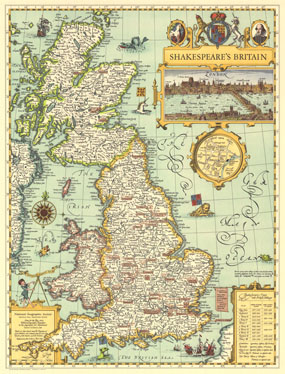
This elegant map of Shakespeare's Britain is based on John Speed's map "The Kingdome of Great Britaine" from his 1611 atlas "Theatre of the Empire of Great Britaine." Published in May 1964, this delightfully illustrated map shows the settings of plays and various points of interest throughout England, Wales, and Scotland. Perfect for framing and a wonderful collector's piece for those interested in the Bard and his Britain.

The 1964 Shakespeare's Britain map features:
• Insets of Stratford-upon-Avon and London
• Shakespeare's plays with British settings
• Towns, abbeys and churches, castles, battlefields, and forests and heath
• Settings of plays noted

Coverage Area: England, Wales, Scotland

More Product Details

This map requires 7 business days to print and laminate prior to shipping.

Appearing in the May 1964 issue of the National Geographic Magazine, this Shakespeares Britain map has been reproduced from its original cartography in order to bring to life a beautiful poster previously only seen in National Geographic Magazine. This reproduction holds true to the high standards that National Geographic Maps are known for.

Perfect for home, office or classroom, this map also makes a great gift. Map collectors will surely want to add this map to their library.

The Paper version is printed on high quaility semi-gloss paper, perfect for framing.

The Laminated version uses 3mm laminate on both sides for durability, is easy to clean and markable.

From the National Geographic Classic Maps collection, this reproduction is just one of hundreds of titles available here. These maps are Printed on Demand. Sizes are approximate and may vary due to the nature of the trimming and laminating processes.
Shipping Conditions
Maps.com ships to Dometic US only

US FlagThis product can only be shipped to the Domestic U.S.A. (No APO's or PO Boxes)
TimeThis map requires 2 business days to print and laminate prior to shipping.