 |
|
|
|
|
France, Belgium And The Netherlands Map 1960
Issue: June 1960
|
|
|
|
|
|
|
| Product Highlights |
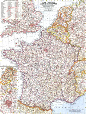
| France, Belgium And The Netherlands Map 1960 |
| Item#: X NGC 061960 |
This detailed map of France, Belgium and the Netherlands includes inset maps of Paris, Amsterdam, and Brussels, as well as a list of the departments or provinces of each country and their capitals. Published in June 1960, this map is unique in its focus on these three particular countries. The 1960 France, Belgium and the Netherlands map features:
• Departments of France, provinces of Belgium and the Netherlands with their capitals
• Inset maps of Amsterdam, Brussels, and Paris
• Thousands of place names including capitals, cities, and towns
• Superhighways, railroads, roads, canals, and places with scheduled air service
• Mountains, passes, rivers, lakes, and areas below sea level
• Oil fields and pipelines
Coverage Area: France, Belgium, Netherlands, Luxembourg
|
|
 |
More Product Details
This map requires 7 business days to print and laminate prior to shipping.
Appearing in the June 1960 issue of the National Geographic Magazine, this France, Belgium And The Netherlands map has been reproduced from its original cartography in order to bring to life a beautiful poster previously only seen in National Geographic Magazine. This reproduction holds true to the high standards that National Geographic Maps are known for.
Perfect for home, office or classroom, this map also makes a great gift. Map collectors will surely want to add this map to their library.
The Paper version is printed on high quaility semi-gloss paper, perfect for framing.
The Laminated version uses 3mm laminate on both sides for durability, is easy to clean and markable.
From the National Geographic Classic Maps collection, this reproduction is just one of hundreds of titles available here. These maps are Printed on Demand. Sizes are approximate and may vary due to the nature of the trimming and laminating processes.
|
|
Shipping Conditions
Maps.com ships to Dometic US only
 | This product can only be shipped to the Domestic U.S.A. (No APO's or PO Boxes) |  | This map requires 2 business days to print and laminate prior to shipping. |
|
|
|
|


 Click here to zoom!