SHOP BY YEAR :: FOR OFFICE :: FOR CLASSROOM :: GIFT IDEAS :: CUSTOMER SERVICE

Europe Map 1915 with Africa and Asia
Issue: July 1915
More Views
Enlarge Image
ZoomClick here to zoom!
Purchase Product :
Please select map format:
Laminated   
31" x 28" - $39.95
Laminated-w/Plastic Rails  (What are rails?)
31" x 28" - $51.95
Paper
31" x 28" - $29.95
Wallzilla Adhesive Format
31" x 28" - $59.95
Product Highlights
Europe Map 1915 with Africa and Asia
Item#: X NGC 071915

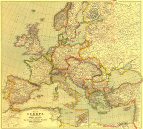
This beautifully rendered map of Europe was published in July 1915, one year into the First World War. A historical snapshot of a region in turmoil, this map is a must-have for map collectors, as well as those interested in The Great War. A National Geographic classic.

The 1915 Europe map with portions of Africa and Asia features:
• Detailed inset of the Dardanelles
• Colorful, distinct country borders
• Thousands of place names including capitals, cities, and towns
• Intricately rendered mountain ranges and rivers
• Railroads and ship canals

Coverage Area: Europe, western Turkish Empire, western Russia

More Product Details

This map requires 7 business days to print and laminate prior to shipping.

Appearing in the July 1915 issue of the National Geographic Magazine, this Europe map with portions of Africa and Asia has been reproduced from its original cartography in order to bring to life a beautiful poster previously only seen in National Geographic Magazine. This reproduction holds true to the high standards that National Geographic Maps are known for.

Perfect for home, office or classroom, this map also makes a great gift. Map collectors will surely want to add this map to their library.

The Paper version is printed on high quaility semi-gloss paper, perfect for framing.

The Laminated version uses 3mm laminate on both sides for durability, is easy to clean and markable.

From the National Geographic Classic Maps collection, this reproduction is just one of hundreds of titles available here. These maps are Printed on Demand. Sizes are approximate and may vary due to the nature of the trimming and laminating processes.
Shipping Conditions
Maps.com ships to Dometic US only

US FlagThis product can only be shipped to the Domestic U.S.A. (No APO's or PO Boxes)
TimeThis map requires 2 business days to print and laminate prior to shipping.