 |
|
|
|
|
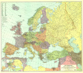
Europe, And The Near East Map 1929
Issue: December 1929
|
|
|
|
|
|
|
| Product Highlights |
| Europe, And The Near East Map 1929 |
| Item#: X NGC 121929 |
This colorful map was published in December 1929 with three articles on Europe and the Near East including "The Danube, Highway of Races." An inset map of airways is included, showing commercial air travel in its infancy. The 1929 Europe and the Near East map features:
• Names of countries in English and the national language
• Inset map of airways
• Capitals and major cities
• Railroads (both through routes and connecting lines), canals, tunnels, and passes
• Major rivers and lakes, swampy regions, and glaciers
• Ruins
• Geographical equivalents
Coverage Area: Europe, western USSR, Turkey, Syria, northern Iraq, northern Persia
|
|
 |
More Product Details
This map requires 7 business days to print and laminate prior to shipping.
Appearing in the December 1929 issue of the National Geographic Magazine, this Europe, And The Near East map has been reproduced from its original cartography in order to bring to life a beautiful poster previously only seen in National Geographic Magazine. This reproduction holds true to the high standards that National Geographic Maps are known for.
Perfect for home, office or classroom, this map also makes a great gift. Map collectors will surely want to add this map to their library.
The Paper version is printed on high quaility semi-gloss paper, perfect for framing.
The Laminated version uses 3mm laminate on both sides for durability, is easy to clean and markable.
From the National Geographic Classic Maps collection, this reproduction is just one of hundreds of titles available here. These maps are Printed on Demand. Sizes are approximate and may vary due to the nature of the trimming and laminating processes.
|
|
Shipping Conditions
Maps.com ships to Dometic US only
 | This product can only be shipped to the Domestic U.S.A. (No APO's or PO Boxes) |  | This map requires 2 business days to print and laminate prior to shipping. |
|
|
|
|


 Click here to zoom!