SHOP BY YEAR :: FOR OFFICE :: FOR CLASSROOM :: GIFT IDEAS :: CUSTOMER SERVICE

Middle East: States In Turmoil Map 1991
Issue: February 1991
More Views
Enlarge Image
ZoomClick here to zoom!
Purchase Product :
Please select map format:
Laminated   
20" x 24.5" - $19.95
Laminated-w/Plastic Rails  (What are rails?)
20" x 24.5" - $29.95
Paper
20" x 24.5" - $14.95
Wallzilla Adhesive Format
20" x 24.5" - $34.95
Product Highlights
Middle East: States In Turmoil Map 1991
Item#: X NGC 021991b

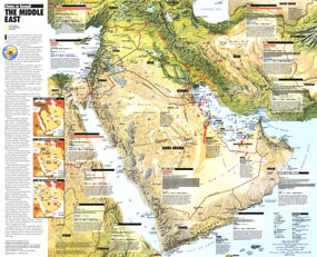
The "Middle East: States in Turmoil" map supplements the Middle East map published in the same issue in February 1991. A fine relief map forms the basis of this informative work which highlights each country's military facilities, population, troops, oil reserves, gross national product, and more. An overview of the Gulf War is included.

The 1991 Middle East States In Turmoil map features:
• Relief map of the region with international boundaries, capitals, and selected cities
• Each country's population, gross national product per capita, oil reserves, troops, tanks, and combat aircraft
• A brief overview of each country
• Military facilities, transients camps, nuclear reactors, and chemical plants
• Three historical maps showing the chain of alliances in 1900, European imperialism in 1919, and the rise of nationalism in 1948
• A brief history of the Gulf War
• Oil fields, pipelines, refineries, and tanker terminals

Coverage Area: Iran, Iraq, Kuwait, Bahrain, Qatar, United Arab Emirates, Oman, Yemen, Saudi Arabia, Israel, Lebanon, Jordan, Cyprus, eastern Egypt, southern Turkey

More Product Details

This map requires 7 business days to print and laminate prior to shipping.

Appearing in the February 1991 issue of the National Geographic Magazine, this Middle East States In Turmoil map has been reproduced from its original cartography in order to bring to life a beautiful poster previously only seen in National Geographic Magazine. This reproduction holds true to the high standards that National Geographic Maps are known for.

Perfect for home, office or classroom, this map also makes a great gift. Map collectors will surely want to add this map to their library.

The Paper version is printed on high quaility semi-gloss paper, perfect for framing.

The Laminated version uses 3mm laminate on both sides for durability, is easy to clean and markable.

From the National Geographic Classic Maps collection, this reproduction is just one of hundreds of titles available here. These maps are Printed on Demand. Sizes are approximate and may vary due to the nature of the trimming and laminating processes.
Shipping Conditions
Maps.com ships to Dometic US only

US FlagThis product can only be shipped to the Domestic U.S.A. (No APO's or PO Boxes)
TimeThis map requires 2 business days to print and laminate prior to shipping.