SHOP BY YEAR :: FOR OFFICE :: FOR CLASSROOM :: GIFT IDEAS :: CUSTOMER SERVICE

Bible Lands, And The Cradle Of Western Civilization Map 1938
Issue: December 1938
More Views
Enlarge Image
ZoomClick here to zoom!
Purchase Product :
Please select map format:
Laminated   
34.5" x 24.5" - $39.95
Laminated-w/Plastic Rails  (What are rails?)
34.5" x 24.5" - $51.95
Paper
34.5" x 24.5" - $29.95
Wallzilla Adhesive Format
34.5" x 24.5" - $59.95
Product Highlights
Bible Lands, And The Cradle Of Western Civilization Map 1938
Item#: X NGC 121938

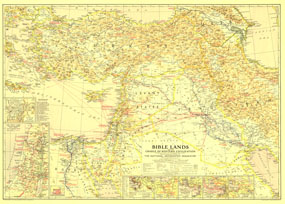
This instructive map is a collectors item for anyone interested in the lands of the Bible. Multiple inset maps detail historical periods such as the route of the Exodus and the Crusades, and the main map contains historical facts as well as information about archaeological finds. Published in December 1938, the map accompanied the article "Change Comes to Bible Lands."

The 1938 Bible Lands, and the Cradle of Western Civilization map features:
• Inset maps of Jerusalem and the Holy Land from Dan to Beersheba
• Historical insets showing economic development, the route of the Exodus, St. Pauls travels, the Crusades, and the empire and army routes of Alexander the Great
• A map showing comparative areas and latitudes of the Bible Lands and the United States
• Capitals of countries, other capitals, cities, towns, principal archaeological sites, ruins, and battle sites
• Easy to spot historical notes in red
• Desert bus routes, airways, railways, and canals
• Oil fields, pipelines, and pumping stations, as well a geographical details including mountains, lakes, rivers, wadies, swamps, deserts, and more

Coverage Area: Turkey, Cyprus, Levant States, Iraq, Transjordan, Palestine, Kuwait, western Iran, northeastern Egypt

More Product Details

This map requires 7 business days to print and laminate prior to shipping.

Appearing in the December 1938 issue of the National Geographic Magazine, this Bible Lands, And The Cradle Of Western Civilization map has been reproduced from its original cartography in order to bring to life a beautiful poster previously only seen in National Geographic Magazine. This reproduction holds true to the high standards that National Geographic Maps are known for.

Perfect for home, office or classroom, this map also makes a great gift. Map collectors will surely want to add this map to their library.

The Paper version is printed on high quaility semi-gloss paper, perfect for framing.

The Laminated version uses 3mm laminate on both sides for durability, is easy to clean and markable.

From the National Geographic Classic Maps collection, this reproduction is just one of hundreds of titles available here. These maps are Printed on Demand. Sizes are approximate and may vary due to the nature of the trimming and laminating processes.
Shipping Conditions
Maps.com ships to Dometic US only

US FlagThis product can only be shipped to the Domestic U.S.A. (No APO's or PO Boxes)
TimeThis map requires 2 business days to print and laminate prior to shipping.