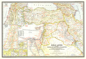
A must-have for Bible scholars and a perfect companion to the Bible Lands map of 1938, this informative map holds an abundance of details about the history of the region. Appearing in National Geographic in December 1946 alongside the article "Syria and Lebanon Taste Freedom," this work captures both the cradle of western civilization in Biblical times and the Holy Land of the late 1940s. The 1946 Bible Lands, and the Cradle of Western Civilization map features:
• Inset maps of Jerusalem, the Holy Land in Biblical times, and the region as it existed in 1946
• Historical insets showing the traditional route of the Exodus, St. Pauls travels, and the Crusades
• Capitals of countries, cities, towns, principal archaeological sites, ruins, and battle sites
• An abundance of historical notes
• Roads, principal railways, and canals
• Geographical details including mountains, lakes, rivers, wadies, deserts, volcanic debris, and water holes
• Oil fields, pipelines, pumping stations, and refineries
Coverage Area: Turkey, Cyprus, Syria, Iraq, Transjordan, Palestine, Lebanon, Kuwait, western Iran, northeastern Egypt
|


 Click here to zoom!
