SHOP BY YEAR :: FOR OFFICE :: FOR CLASSROOM :: GIFT IDEAS :: CUSTOMER SERVICE

Lands Of The Bible Today Map 1956
Issue: December 1956
More Views
Enlarge Image
ZoomClick here to zoom!
Purchase Product :
Please select map format:
Laminated   
41" x 29" - $59.95
Laminated-w/Plastic Rails  (What are rails?)
41" x 29" - $76.95
Paper
41" x 29" - $49.95
Wallzilla Adhesive Format
41" x 29" - $89.95
Product Highlights
Lands Of The Bible Today Map 1956
Item#: X NGC 121956

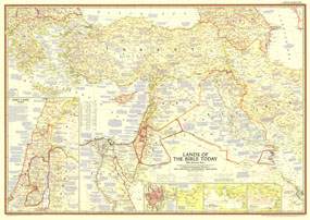
Attractive cartography and copious historical information make this map of the Holy Land a true collectors item and perfect companion to the maps of 1938 and 1946. Published in December 1956 with the article "Jerusalem to Rome in the Path of St. Paul," it also reveals the locations of the Seven Wonders of the Ancient World and contains references to Bible passages alongside relevant place names.

The 1956 Lands of the Bible Today map features:
• Inset maps of Jerusalem and the Holy Land as it existed in 1956
• Historical insets showing the traditional route of the Exodus, St. Pauls four great journeys, and the Crusades
• Thousands of place names including capitals of countries, cities, and towns
• An abundance of historical notes, archaeological sites, ruins, battle sites, and the locations of the Seven Wonders of the Ancient World
• Airports, roads, railways (both existing and under construction), and canals
• Geographical details including mountains, lakes, intermittent lakes, dry salt lakes, rivers, deserts, volcanic debris, water holes, and areas below sea level
• Oil fields, pipelines, pumping stations, and refineries

Coverage Area: Greece, Turkey, Cyprus, Syria, Iraq, Jordan, Israel, Lebanon, Kuwait, western Iran, northeastern Egypt

More Product Details

This map requires 7 business days to print and laminate prior to shipping.

Appearing in the December 1956 issue of the National Geographic Magazine, this Lands Of The Bible Today map has been reproduced from its original cartography in order to bring to life a beautiful poster previously only seen in National Geographic Magazine. This reproduction holds true to the high standards that National Geographic Maps are known for.

Perfect for home, office or classroom, this map also makes a great gift. Map collectors will surely want to add this map to their library.

The Paper version is printed on high quaility semi-gloss paper, perfect for framing.

The Laminated version uses 3mm laminate on both sides for durability, is easy to clean and markable.

From the National Geographic Classic Maps collection, this reproduction is just one of hundreds of titles available here. These maps are Printed on Demand. Sizes are approximate and may vary due to the nature of the trimming and laminating processes.
Shipping Conditions
Maps.com ships to Dometic US only

US FlagThis product can only be shipped to the Domestic U.S.A. (No APO's or PO Boxes)
TimeThis map requires 2 business days to print and laminate prior to shipping.