 |
|
|
|
|
Special Places Of The World, Holy Land Map 1989 Side 2
Issue: December 1989
|
|
|
|
|
|
|
| Product Highlights |
| Special Places Of The World, Holy Land Map 1989 Side 2 |
| Item#: X NGC 121989b |
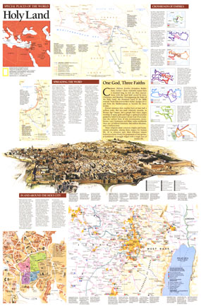
Half of a two-page layout on the Holy Land, this educational supplement teems with details of the history of the land held sacred by Jews, Christians, and Muslims. An extraordinary illustration of Jerusalem notes important sites and the Crossroads of Empires inset reveals the history of the regions occupation. Printed in December 1989, this work stands alone or perfectly compliments the map of the Holy Land that appeared in the same issue. The 1989 "Special Places of the World, Holy Land" map side 2 features:
• A compelling illustration of Jerusalem with historical sites noted
• A Crossroads of Empire inset that reveals the conquest and occupation of the region through the ages
• The journeys of Abraham, Paul, and Mohammad
• An abundance of historical information about the various inhabitants of the region
• Sites are noted by historical period, from Stone and Bronze Ages (CA 500,000 to 1200 B.C.) to the Islamic Period (A.D. 640 to 1917)
• Sites are marked with symbols to denote the religions associated with that site
• Information about the origins of Judaism, Christianity, and Islam
Coverage Area: Israel
|
|
 |
More Product Details
This map requires 7 business days to print and laminate prior to shipping.
Appearing in the December 1989 issue of the National Geographic Magazine, this Special Places Of The World, Holy Land map has been reproduced from its original cartography in order to bring to life a beautiful poster previously only seen in National Geographic Magazine. This reproduction holds true to the high standards that National Geographic Maps are known for.
Perfect for home, office or classroom, this map also makes a great gift. Map collectors will surely want to add this map to their library.
The Paper version is printed on high quaility semi-gloss paper, perfect for framing.
The Laminated version uses 3mm laminate on both sides for durability, is easy to clean and markable.
From the National Geographic Classic Maps collection, this reproduction is just one of hundreds of titles available here. These maps are Printed on Demand. Sizes are approximate and may vary due to the nature of the trimming and laminating processes.
|
|
Shipping Conditions
Maps.com ships to Dometic US only
 | This product can only be shipped to the Domestic U.S.A. (No APO's or PO Boxes) |  | This map requires 2 business days to print and laminate prior to shipping. |
|
|
|
|


 Click here to zoom!