SHOP BY YEAR :: FOR OFFICE :: FOR CLASSROOM :: GIFT IDEAS :: CUSTOMER SERVICE

West Indies And Central America Map 1970
Issue: January 1970
More Views
Enlarge Image
ZoomClick here to zoom!
Purchase Product :
Please select map format:
Laminated   
38" x 26.5" - $59.95
Laminated-w/Plastic Rails  (What are rails?)
38" x 26.5" - $76.95
Paper
38" x 26.5" - $49.95
Wallzilla Adhesive Format
38" x 26.5" - $89.95
Product Highlights
West Indies And Central America Map 1970
Item#: X NGC 011970

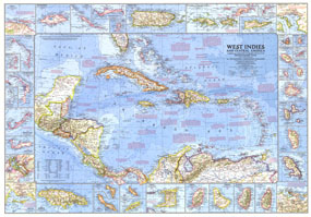
This wonderfully detailed map of the West Indies and Central America was published in January 1970 with the article "The Netherlands Antilles: Holland in the Caribbean." It includes inset maps of over thirty islands, four cities, and the Panama Canal. A particularly unique feature of this map is the splashdown points of various space missions.

The 1970 West Indies and Central America map features:
• Inset maps of over thirty islands
• Maps of the Panama Canal Zone and the cities of Kingston, Nassau, Charlotte Amalie, and San Juan
• Historical notes including splashdown sites of space missions
• Ocean bathymetry, prevailing winds, and warm currents
• Capitals, cities, and towns
• Superhighways, roads, railroads, canals, and places with scheduled air service
• Ruins, oil fields, and oil pipelines

Coverage Area: Central America, West Indies

More Product Details

This map requires 7 business days to print and laminate prior to shipping.

Appearing in the January 1970 issue of the National Geographic Magazine, this West Indies And Central America map has been reproduced from its original cartography in order to bring to life a beautiful poster previously only seen in National Geographic Magazine. This reproduction holds true to the high standards that National Geographic Maps are known for.

The Paper version is printed on high quaility semi-gloss paper, perfect for framing.

The Laminated version uses 3mm laminate on both sides for durability, is easy to clean and markable.

From the National Geographic Classic Maps collection, this reproduction is just one of hundreds of titles available here. These maps are Printed on Demand. Sizes are approximate and may vary due to the nature of the trimming and laminating processes.
Shipping Conditions
Maps.com ships to Dometic US only

US FlagThis product can only be shipped to the Domestic U.S.A. (No APO's or PO Boxes)
TimeThis map requires 2 business days to print and laminate prior to shipping.